White Rim Sandstone
| White Rim Sandstone Stratigraphic range: Early to Middle Permian, 275–272 Ma | |
|---|---|
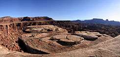
.jpg) White Rim Sandstone, Canyonlands National Park | |
| Type | Geological formation |
| Unit of | Cutler Formation |
| Underlies | Kaibab Formation, Circle Cliffs, Utah |
| Overlies |
Organ Rock Formation, southeast Utah; Organ Rock and Toroweap Formation, Circle Cliffs |
| Thickness | 500 feet (150 m) approximate maximum[1] |
| Lithology | |
| Primary | (white)-sandstone |
| Location | |
| Region |
central & east-Colorado Plateau south and southeast Utah |
| Extent | Circle Cliffs, west of Waterpocket Fold; Moab Utah region |
White Rim Sandstone is a sandstone geologic formation located in southeastern Utah.
Geology
It is the continental geologic formation deposited at the time of marine transgressions during the Early to Middle Permian Period.
- Toroweap Formation
The coeval Toroweap Formation was laid down under marine conditions along the southwest margin of the North American continent and is found in northwest Arizona layered between Coconino Sandstone and the Kaibab Formation. The Toroweap is mostly from the Grand Canyon and just eastwards to Lee's Ferry-(Colorado River, Grand Canyon), south to the Verde Valley region (Sedona, Sycamore Canyon, Oak Creek Canyon), but the Toroweap also occurs within sections in southeast Utah, and also became overlain by the Kaibab Formation, specifically at the Circle Cliffs, west of the Waterpocket Fold.
Geography
The White Rim Sandstone typically occurs above the Organ Rock Formation in southeast Utah, which sits upon the extensive Cedar Mesa Sandstone in southeast Utah.[2]
Occurrences in Utah
Moab, Utah, is located in southeast Utah, about 25 miles (40 km) west of the Colorado border.[3] The Circle Cliffs lie about 90 miles (145 km) southwest from Moab,[4] and east of Escalante and Boulder, Utah (Utah State Route 12).[5] The Circle Cliffs are located in the northeast of Grand Staircase-Escalante National Monument. The cliffs also extend north-northwest adjacent the west perimeter of the Waterpocket Fold, Capitol Reef National Park. The fold is traversed by Burr Trail Road-Straton Road which has views toward the Circle Cliffs, southward, or westward.
The White Rim Road traverses the White Rim Sandstone formation between the base of the Island in the Sky mesa and the Colorado and Green Rivers within Canyonlands National Park.
- Circle Cliffs, (extreme south)-southeast-Utah
- Moenkopi Formation
- Toroweap Formation-White Rim Sandstone
- Organ Rock Formation
- Cedar Mesa Sandstone
- Moab, Utah — W. Colorado
- Moenkopi Formation
- White Rim Sandstone
- Organ Rock Formation
- Cedar Mesa Sandstone
See also
| Wikimedia Commons has media related to White Rim Sandstone. |
Gallery
|
|

References
- ↑ Blakey, Ranney, 2008. Ancient Landscapes of the Colorado Plateau, p. XVIII.
- ↑ Blakey, Ranney, 2008. Ancient Landscapes of the Colorado Plateau, p. XVIII, and Cross section restored to the end of Permian time showing how Pennsylvanian and Permian rocks thicken and thin across the tectonic elements.-(4,000-10,000 ft), p. 34.
- ↑ Utah DeLorme Atlas & Gazetteer, pp. 32-33.
- ↑ Utah DeLorme Atlas, pp. 32-33.
- ↑ Utah DeLorme Atlas, p. 52.
Further reading
- Blakey, and Ranney, 2008. Ancient Landscapes of the Colorado Plateau, Ron Blakey, Wayne Ranney, c 2008, Grand Canyon Association (publisher), 176 pages, with Appendix, Glossary, Index. Contains approximately 75 shaded topographic maps, for geology, etc., with 54 (23 pairs, (46)) for Colorado Plateau specifically; others are global, or North American.
- Utah DeLorme Atlas & Gazetteer, 7th Edition, c. 2010, 64 pages, pp. 24, 32.