White Owl, South Dakota
| White Owl | |
|---|---|
| Unincorporated community | |
 White Owl Location within the state of South Dakota  White Owl White Owl (the US) | |
| Coordinates: 44°35′32″N 102°25′51″W / 44.59222°N 102.43083°WCoordinates: 44°35′32″N 102°25′51″W / 44.59222°N 102.43083°W | |
| Country | United States |
| State | South Dakota |
| County | Meade |
| Named for | White Owl Creek |
| Elevation | 2,792 ft (851 m) |
| Time zone | UTC-7 (Mountain (MST)) |
| • Summer (DST) | UTC-6 (MDT) |
| ZIP codes | 57792 |
| Area code(s) | 605 |
| FIPS code | 46-71260[1] |
| GNIS feature ID | 1258970[1] |
White Owl (also Whiteowl) is an unincorporated rural village in east central Meade County, South Dakota, United States, with a population of 61 as of the 2010 census. It lies along Highway 34 55 miles (89 km) east of the city of Sturgis, the county seat.[2] Its elevation is 2,792 feet (851 m). The village has a fashion boutique, a Baptist church, a Community Center, a graveyard, and a post office, with the ZIP code of 57792.[3]
The community took its name from nearby White Owl Creek.[4]
References
- 1 2 "US Board on Geographic Names". United States Geological Survey. 2007-10-25. Retrieved 2008-01-31.
- ↑ Rand McNally. The Road Atlas '05. Chicago: Rand McNally, 2005, p. 93.
- ↑ Zip Code Lookup
- ↑ Federal Writers' Project (1940). South Dakota place-names, v.1-3. University of South Dakota. p. 68.
Municipalities and communities of Meade County, South Dakota, United States | ||
|---|---|---|
| Cities | 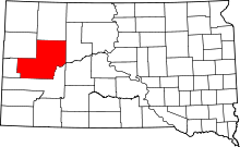 | |
| CDPs | ||
| Former CDP | ||
| Unincorporated communities | ||
| Indian reservations | ||
| Ghost towns | ||
| Footnotes | ‡This populated place also has portions in an adjacent county or counties | |
This article is issued from
Wikipedia.
The text is licensed under Creative Commons - Attribution - Sharealike.
Additional terms may apply for the media files.