Enning, South Dakota
| Enning | |
|---|---|
| Unincorporated community | |
 Enning Location within the state of South Dakota  Enning Enning (the US) | |
| Coordinates: 44°34′32″N 102°33′46″W / 44.57556°N 102.56278°WCoordinates: 44°34′32″N 102°33′46″W / 44.57556°N 102.56278°W | |
| Country | United States |
| State | South Dakota |
| County | Meade |
| Time zone | UTC-7 (Mountain (MST)) |
| • Summer (DST) | UTC-6 (MDT) |
| ZIP codes | 57737 |
| Area code(s) | 605 |
Enning is an unincorporated community in Meade County, South Dakota, United States. The community sits at an elevation of 3,035 feet (925 m) and was named in honor of Anna Enning's land grant for a school.[1] Although not tracked by the Census Bureau, Enning has been assigned the ZIP code of 57737.[2]
The first settlement at Enning was made in 1910.[3]
References
- ↑ "Enning". Geographic Names Information System. United States Geological Survey. Retrieved 28 November 2014.
- ↑ "Look Up a ZIP Code™". USPS. Retrieved 28 November 2014.
- ↑ Federal Writers' Project (1940). South Dakota place-names, v.1-3. University of South Dakota. p. 37.
Municipalities and communities of Meade County, South Dakota, United States | ||
|---|---|---|
| Cities | 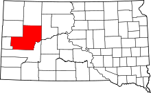 | |
| CDPs | ||
| Former CDP | ||
| Unincorporated communities | ||
| Indian reservations | ||
| Ghost towns | ||
| Footnotes | ‡This populated place also has portions in an adjacent county or counties | |
This article is issued from
Wikipedia.
The text is licensed under Creative Commons - Attribution - Sharealike.
Additional terms may apply for the media files.