Wheeler's Point, Minnesota
| Wheeler's Point, Minnesota | |
|---|---|
| Unincorporated community | |
 Wheeler's Point, Minnesota  Wheeler's Point, Minnesota | |
| Coordinates: 48°50′16″N 94°41′52″W / 48.837761°N 94.697709°WCoordinates: 48°50′16″N 94°41′52″W / 48.837761°N 94.697709°W | |
| Country | United States |
| State | Minnesota |
| County | Lake of the Woods |
| Elevation | 1,070 ft (330 m) |
| Time zone | UTC-6 (Central (CST)) |
| • Summer (DST) | UTC-5 (CDT) |
| Area code(s) | 218 |
| GNIS feature ID | 654059[1] |
Wheeler's Point is an unincorporated community in Wheeler Township, Lake of the Woods County, Minnesota, United States. It is 12 miles north of Baudette.
County Road 8 and Minnesota State Highway 172 are two of the main routes in the community.
Wheeler's Point is located at the Four Mile Bay at the southern end of the Lake of the Woods. The entry to the Rainy River is also at this point.
The community of Hackett and Zippel Bay State Park are also nearby.
References
Further reading
- Rand McNally Road Atlas - 2007 edition - Minnesota entry
- Official State of Minnesota Highway Map - 2007/2008 edition
Municipalities and communities of Lake of the Woods County, Minnesota, United States | ||
|---|---|---|
| Cities | 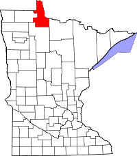 | |
| Townships | ||
| CDP | ||
| Unincorporated communities |
| |
| Indian reservations | ||
| Ghost towns | ||
| Footnotes | ‡This populated place also has portions in an adjacent county or counties | |
This article is issued from
Wikipedia.
The text is licensed under Creative Commons - Attribution - Sharealike.
Additional terms may apply for the media files.