Angle Inlet, Minnesota
| Angle Inlet, Minnesota | |
|---|---|
| Census-designated place (CDP) & Unincorporated community | |
 Angle Inlet, Minnesota Location in Minnesota and the United States  Angle Inlet, Minnesota Angle Inlet, Minnesota (the US) | |
| Coordinates: 49°20′42″N 95°4′12″W / 49.34500°N 95.07000°WCoordinates: 49°20′42″N 95°4′12″W / 49.34500°N 95.07000°W | |
| Country | United States |
| State | Minnesota |
| County | Lake of the Woods |
| Area[1] | |
| • Total | 2.017 sq mi (5.22 km2) |
| • Land | 1.736 sq mi (4.50 km2) |
| • Water | 0.281 sq mi (0.73 km2) |
| Elevation | 1,063 ft (324 m) |
| Population (2010)[2] | |
| • Total | 60 |
| • Density | 30/sq mi (11/km2) |
| Time zone | UTC-6 (Central (CST)) |
| • Summer (DST) | UTC-5 (CDT) |
| Zip Code | 56711 |
| Area code(s) | 218 |
| GNIS feature ID | 639371[3] |
Angle Inlet is a census-designated place (CDP) and unincorporated community in Angle Township, Lake of the Woods County, Minnesota, United States. Its population was 60 as of the 2010 census.[2] The community is part of the Northwest Angle, the only place in the contiguous United States north of the 49th parallel; it is the northernmost census-designated place in the contiguous United States.[4] The French built Fort Saint Charles nearby in 1732.
Angle Inlet has the last one-room school in the state[5] and a post office with a sign stating that it is the "Most Northerly P.O. in Contiguous U.S."[6] To travel to Angle Inlet from other parts of Minnesota by road requires driving through Manitoba, Canada.
References
| Wikivoyage has a travel guide for Angle Inlet. |
- ↑ "US Gazetteer files: 2010, 2000, and 1990". United States Census Bureau. 2011-02-12. Retrieved 2011-04-23.
- 1 2 "American FactFinder". United States Census Bureau. Archived from the original on 2013-09-11. Retrieved 2011-05-14.
- ↑ "Angle Inlet". Geographic Names Information System. United States Geological Survey.
- ↑ Lake of the Woods Co. General Highway Map (PDF) (Map). 2011. p. 3. Archived from the original (PDF) on 2012-09-04. Retrieved March 9, 2012.
- ↑ Ross, Jenna (June 1, 2015). "Minnesota's last one-room schoolhouse counts on its longtime teacher". Star Tribune. Minneapolis, Minnesota.
- ↑ "Chapter 4: The Watery Boundary". United Divide: A Linear Portrait of the USA/Canada Border. The Center for Land Use Interpretation. Winter 2015.
Municipalities and communities of Lake of the Woods County, Minnesota, United States | ||
|---|---|---|
| Cities | 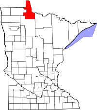 | |
| Townships | ||
| CDP | ||
| Unincorporated communities |
| |
| Indian reservations | ||
| Ghost towns | ||
| Footnotes | ‡This populated place also has portions in an adjacent county or counties | |
This article is issued from
Wikipedia.
The text is licensed under Creative Commons - Attribution - Sharealike.
Additional terms may apply for the media files.