Graceton, Minnesota
| Graceton, Minnesota | |
|---|---|
| Former community | |
 Graceton, Minnesota  Graceton, Minnesota | |
| Coordinates: 48°44′28″N 94°50′11″W / 48.74111°N 94.83639°WCoordinates: 48°44′28″N 94°50′11″W / 48.74111°N 94.83639°W | |
| Country | United States |
| State | Minnesota |
| County | Lake of the Woods |
| Elevation | 1,135 ft (346 m) |
| Time zone | UTC-6 (Central (CST)) |
| • Summer (DST) | UTC-5 (CDT) |
| Area code(s) | 218 |
| GNIS feature ID | 644307[1] |
Graceton was an unincorporated community in Lake of the Woods County, Minnesota, United States.
The community is located west of Baudette on Minnesota Highway 11 at the intersection with Lake of the Woods County Road 4. It once had a station on the Canadian Pacific line, but is now a whistle stop.
Graceton was largely burned to the ground in the Baudette Fire of 1910.[2]
References
- ↑ "Clementson". Geographic Names Information System. United States Geological Survey.
- ↑ "The Fire of 1910". Lake of the Woods County Historical Society. Retrieved 2009-06-08.
Further reading
- Rand McNally Road Atlas - 2007 edition - Minnesota entry
- Official State of Minnesota Highway Map - 2007/2008 edition
Municipalities and communities of Lake of the Woods County, Minnesota, United States | ||
|---|---|---|
| Cities | 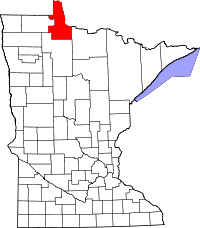 | |
| Townships | ||
| CDP | ||
| Unincorporated communities |
| |
| Indian reservations | ||
| Ghost towns | ||
| Footnotes | ‡This populated place also has portions in an adjacent county or counties | |
This article is issued from
Wikipedia.
The text is licensed under Creative Commons - Attribution - Sharealike.
Additional terms may apply for the media files.