Weyburn Airport
| Weyburn Airport | |||||||||||||||
|---|---|---|---|---|---|---|---|---|---|---|---|---|---|---|---|
 Weyburn Airport | |||||||||||||||
| Summary | |||||||||||||||
| Airport type | Public | ||||||||||||||
| Operator | Town of Weyburn | ||||||||||||||
| Location | Weyburn No. 67, near Weyburn, Saskatchewan | ||||||||||||||
| Time zone | CST (UTC−06:00) | ||||||||||||||
| Elevation AMSL | 1,934 ft / 589 m | ||||||||||||||
| Coordinates | 49°41′51″N 103°48′03″W / 49.69750°N 103.80083°WCoordinates: 49°41′51″N 103°48′03″W / 49.69750°N 103.80083°W | ||||||||||||||
| Map | |||||||||||||||
 CJE3 Location in Saskatchewan  CJE3 CJE3 (Canada) | |||||||||||||||
| Runways | |||||||||||||||
| |||||||||||||||
|
Source: Canada Flight Supplement[1] | |||||||||||||||
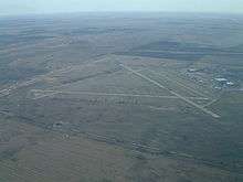
Weyburn Airport, (TC LID: CJE3), is located 2.2 nautical miles (4.1 km; 2.5 mi) northeast of Weyburn, Saskatchewan, Canada.
History
The aerodrome was constructed in 1941 by the Royal Canadian Air Force (RCAF) as part of the British Commonwealth Air Training Plan. The Station was home to No. 41 Service Flying Training School and during its operation graduated 1,055 pilots and recorded more than 180,000 hours of flight time before being abandoned on 30 June 1944.[2] For more information please see RCAF Station Weyburn
Post war
Other uses included a children's physiological hospital in the 1950s and the home of the Western Christian College from 1957 until 1989.[2]
Current use
Some of the original hangars are still in existence.
Two runways remain in operation, while runway 18/36 is abandoned.[2]
References
- ↑ Canada Flight Supplement. Effective 0901Z 19 July 2018 to 0901Z 13 September 2018.
- 1 2 3 "Services > Airport". City of Weyburn. Retrieved 2011-07-16.
External links
| By name | |
|---|---|
| By location indicator | |
| By province/territory | |
| By area | |
| National Airports System | |
| Related | |
| |