Weston-Worle Ridge
| Weston-Worle Ridge | |
|---|---|
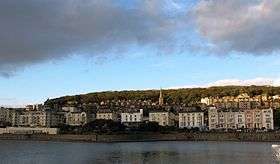 A view of Worlebury Hill, the western peak. | |
| Geography | |
| Location | North Somerset, England |
| Range coordinates | 51°22′N 2°59′W / 51.36°N 2.98°W |
| Geology | |
| Mountain type | Hill |
The Weston-Worle Ridge is a range of three hills just north of Weston-super-Mare. Going from west to east, these hills are Worlebury Hill, Milton Hill, and Worle Hill.[1]
References
- ↑ Sibly, Thomas Franklin. (1905). "The Carboniferous Limestone of the Weston-super-Mare District" (eBook). The Quarterly Journal of the Geological Society of London. Geological Society of London. LXI: 548. doi:10.1144/GSL.JGS.1905.061.01-04.28.
This article is issued from
Wikipedia.
The text is licensed under Creative Commons - Attribution - Sharealike.
Additional terms may apply for the media files.