West Newton station
WEST NEWTON | ||||||||||||||||||||||||||
|---|---|---|---|---|---|---|---|---|---|---|---|---|---|---|---|---|---|---|---|---|---|---|---|---|---|---|
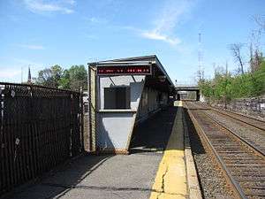 West Newton station in May 2011 | ||||||||||||||||||||||||||
| Location |
1395 Washington Street Newton, Massachusetts | |||||||||||||||||||||||||
| Coordinates | 42°20′52″N 71°13′51″W / 42.34780°N 71.23075°WCoordinates: 42°20′52″N 71°13′51″W / 42.34780°N 71.23075°W | |||||||||||||||||||||||||
| Owned by | MBTA | |||||||||||||||||||||||||
| Line(s) | Worcester Line | |||||||||||||||||||||||||
| Platforms | 1 side platform | |||||||||||||||||||||||||
| Tracks | 2 | |||||||||||||||||||||||||
| Connections | MBTA Buses | |||||||||||||||||||||||||
| Construction | ||||||||||||||||||||||||||
| Parking | 45 spaces ($4.00 fee) | |||||||||||||||||||||||||
| Other information | ||||||||||||||||||||||||||
| Fare zone | 2 | |||||||||||||||||||||||||
| History | ||||||||||||||||||||||||||
| Opened | 1834 | |||||||||||||||||||||||||
| Traffic | ||||||||||||||||||||||||||
| Passengers (2013) | 284 (weekday inbound average)[1] | |||||||||||||||||||||||||
| Services | ||||||||||||||||||||||||||
| ||||||||||||||||||||||||||
West Newton is an MBTA Commuter Rail station in Newton, Massachusetts. It serves the Framingham/Worcester Line, and is located inside the Massachusetts Turnpike Exit 16 rotary in the village of West Newton. Except for a brief period in 1981, West Newton has had rail service since 1834. The station consists of a single low side platform serving one of the line's two tracks, with small crossings to access trains on the far track. West Newton is not handicapped accessible.
History
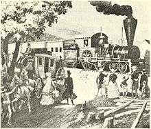
West Newton was the first terminus of the Boston and Worcester Railroad in April 1834, and one of the first locations in the world from which workers could commute to a city by rail for regular working hours. The Railroad Hotel originally served as the train station.[2]
By the late 1840s, a dedicated station building was located on the north side of the tracks just west of Chestnut Street.[3] By the 1870s, West Newton was a flag stop, with a larger station building on the south side of the tracks.[4]
Except for six weeks in 1981, West Newton has had continuous rail service since 1834. As part of service cutbacks due to declining funding, West Newton was closed along with Auburndale, West Gloucester, Uphams Corner, and Morton Street on January 30, 1981.[5] West Newton and Auburndale reopened on March 16, 1981, though the other three stations did not.[5]
A 2011 village plan prepared for the city by MIT proposed a four-story development integrated with a rebuilt commuter rail station, with two high-level side platforms providing handicapped accessible boarding on both tracks.[6]
Bus connections
Two MBTA Bus express routes serve West Newton:
- 553 Roberts - Downtown Boston via Newton Corner & Central Square, Waltham
- 554 Waverley Square - Downtown Boston
References
- ↑ "Ridership and Service Statistics" (PDF) (14th ed.). Massachusetts Bay Transportation Authority. 2014.
- ↑ Harwood, Herbert H. (Spring 1992). "History Where You Don't Expect It: Some Surprising Survivors". Railroad History (166): 103–125. JSTOR 43523701. (Subscription required (help)).
- ↑ Woodward, E.F.; Ward, W.F. (April 1848). "Map of the Town of Newton".
- ↑ "South East Part of West Newton". Atlas of Newton. J.B. Beers & Co. 1874 – via Ward Maps.
- 1 2 Belcher, Jonathan (27 June 2015). "Changes to Transit Service in the MBTA district 1964-2015" (PDF). NETransit. Retrieved 7 December 2015.
- ↑ 2011 Community Growth and Land Use Planning Practicum (December 2011). "WEST NEWTON VILLAGE AREA PLAN" (PDF). MIT Department of Urban Studies and Planning. pp. 146–148.
External links
| Wikimedia Commons has media related to West Newton (MBTA station). |
- MBTA - West Newton
- Washington Street (east) entrance from Google Maps Street View
- Washington Street (west) entrance from Google Maps Street View