West Heath, Cheshire
West Heath is a suburb to the west of Congleton, in Cheshire, England.[1] It is the site of Astbury Mere Country Park. The West Heath area has three schools, with one of Congleton's two secondary schools, Congleton High School being based there.
Geography and environment
Congleton lies at a zone of transition between the Cheshire Plain and Peak District ( Pennine) Mountains. West Heath lies on the Cheshire plain and consists of rolling farmland, suburbs and small woodlands. The River Dane passes through areas of West Heath and much of the areas woodlands are found here. West Heath is notably more affluent than some other areas of Congleton with a strong middle class and skilled working class demographic. Many people commute to other towns to work, notably Greater Manchester, Stoke-on-Trent and Liverpool. The flora of the area is typical of the Cheshire Plain, but is well wooded and with small areas of heathlands still surviving in isolated pockets, mainly around Astbury Mere and out towards Somerford.
History
West Heath was formerly an area of large heathland and woodland. It had an opencast sand quarry, now a lake known as Astbury Mere. Many of the houses and layout were built after the 1960s to the present, although older buildings pocket the area.
West Heath Shopping Centre is located between Holmes Chapel Road and Sandbach Road and hosts a wide range of shops including a Pharmacy, Newsagent, Hardware Store, Aldi, a Chinese restaurant and takeaway called The Happy Garden, an Indian Restaurant, a pub called The Unicorn, and a Fish and Chip Shop.
West Heath was until the 1930s mainly farmland and woodland, and many of the old hawthorn boundary hedges and small woodlands can still be seen.
On the Eastern edge of West Heath towards the town centre is a light-industrial estate that produces components for heavy load vehicles and aircraft as well as having several small businesses and trades such as information technology services.
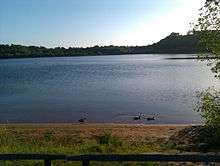
Astbury Mere
Astbury Mere is a local country park and is popular with walkers, dog walkers, cyclists, fishermen and adventure sports enthusiasts.[2] It is just off Newcastle Road, just ten minutes walk from the town centre, with paths linking into the local countryside. It is right on the edge of the Peak District National Park.
Astbury Mere Country Park is owned and managed by the Astbury Mere Trust which is a registered Charity. The Trust is run and governed by volunteer trustees with the day-to-day management being contracted with Cheshire East Council to pay for the services of our long serving ranger. The £40,000+ annual running cost of the park is paid entirely by the Trust without financial support from the local authorities. Therefore, One of the Trusts biggest tasks is to generate sufficient income each year to cover that cost. Entry to the park is free but visitors can make charitable donations.
The park is a former sand quarry that has been converted into a public area;[2] the country park does not extend to the beaches surrounding the lake which are owned and used by anglers from the Stoke-on-Trent Angling Society, although they permit people to use the beaches and have fenced off the beach for dogs to go in the lake.
There is a visitor centre at the country park and also a restaurant and sailing club/school on the opposite side of the lake to the visitor centre.
References
- ↑ Ordnance Survey: Landranger map sheet 118 Stoke-on-Trent & Macclesfield (Map). Ordnance Survey. 2012. ISBN 9780319229064.
- 1 2 "Astbury Mere Country Park". www.cheshireeast.gov.uk. Retrieved 11 April 2016.
External links
![]()
Coordinates: 53°9′40″N 2°14′0″W / 53.16111°N 2.23333°W
Cheshire Portal | |
| Unitary authorities | |
| Major settlements | |
| Rivers | |
| Topics | |