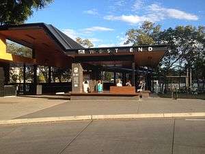
West End ferry wharf
West End | |||||||||||
|---|---|---|---|---|---|---|---|---|---|---|---|
 | |||||||||||
| Location | Orleigh Street, West End | ||||||||||
| Coordinates | 27°29′25″S 153°00′12″E / 27.4902°S 153.0034°ECoordinates: 27°29′25″S 153°00′12″E / 27.4902°S 153.0034°E | ||||||||||
| Owned by | Brisbane City Council | ||||||||||
| Operated by | Transdev Brisbane Ferries | ||||||||||
| Platforms | 1 | ||||||||||
| Construction | |||||||||||
| Disabled access | Yes | ||||||||||
| Other information | |||||||||||
| Station code | 317574 | ||||||||||
| Fare zone | go card 1 | ||||||||||
| History | |||||||||||
| Rebuilt | 24 July 2011 | ||||||||||
| Services | |||||||||||
| |||||||||||
West End ferry wharf is located on the northern side of the Brisbane River serving the Brisbane suburb of West End. It is served by Transdev Brisbane Ferries' CityCat services.[1][2]
The wharf was destroyed during the January 2011 Brisbane floods.[3][4] A new wharf opened on 24 July 2011.[5]
References
- ↑ West End wharf timetable TransLink
- ↑ CityCat timetable Transdev Brisbane Ferries
- ↑ List: CityCat, CityFerry terminal damage Brisbane Times 20 January 2011
- ↑ All CityCat terminals except West End get back on deck The Courier Mail 18 April 2011
- ↑ West End CityCat Terminal Re-Opens After Brisbane Flood Brisbane Times 25 July 2011
External links
![]()
This article is issued from
Wikipedia.
The text is licensed under Creative Commons - Attribution - Sharealike.
Additional terms may apply for the media files.