West Driefontein
| West Driefontein | |
|---|---|
 West Driefontein  West Driefontein West Driefontein (South Africa)  West Driefontein West Driefontein (Africa) | |
| Coordinates: 26°23′S 27°26′E / 26.383°S 27.433°ECoordinates: 26°23′S 27°26′E / 26.383°S 27.433°E | |
| Country | South Africa |
| Province | Gauteng |
| District | West Rand |
| Municipality | Merafong City |
| Area[1] | |
| • Total | 47.54 km2 (18.36 sq mi) |
| Population (2011)[1] | |
| • Total | 2,857 |
| • Density | 60/km2 (160/sq mi) |
| Racial makeup (2011)[1] | |
| • Black African | 97.1% |
| • Coloured | 1.3% |
| • Indian/Asian | 0.4% |
| • White | 1.2% |
| First languages (2011)[1] | |
| • Sotho | 28.4% |
| • Xhosa | 27.2% |
| • Tsonga | 15.0% |
| • Zulu | 13.8% |
| • Other | 15.6% |
| Time zone | UTC+2 (SAST) |
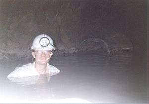
Flooded level, West Driefontein mine, South Africa. The dolomite overlying the gold reefs hosts much groundwater, giving the mines flooding problems.
West Driefontein was a mining company belonging to the Goldfields Group, approximately 10 kilometres (6.2 mi) outside Carletonville next to Blyvooruitsig and East Driefontein. It used to be the richest gold mine in the world.
References
- 1 2 3 4 "Main Place West Driefontein". Census 2011.
Municipalities and communities of West Rand District Municipality, Gauteng | ||
|---|---|---|
District seat: Randfontein | ||
| Mogale City | .svg.png) | |
| Merafong City | ||
| Randfontein | ||
| Westonaria | ||
This article is issued from
Wikipedia.
The text is licensed under Creative Commons - Attribution - Sharealike.
Additional terms may apply for the media files.