West Columbia, West Virginia
| West Columbia, West Virginia | |
|---|---|
| Unincorporated community | |
 West Columbia, West Virginia | |
| Coordinates: 38°58′59″N 82°03′49″W / 38.98306°N 82.06361°WCoordinates: 38°58′59″N 82°03′49″W / 38.98306°N 82.06361°W | |
| Country | United States |
| State | West Virginia |
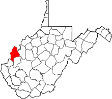
| County | Mason |
| Elevation | 571 ft (174 m) |
| Time zone | UTC-5 (Eastern (EST)) |
| • Summer (DST) | UTC-4 (EDT) |
| ZIP code | 25287 |
| Area code(s) | 304 & 681 |
| GNIS feature ID | 1555941[1] |
West Columbia is an unincorporated community in Mason County, West Virginia, USA. West Columbia is located on the Ohio River and West Virginia Route 62 3 miles (4.8 km) southwest of Mason. West Columbia has a post office with ZIP code 25287.[2]
The community most likely was named after Columbia, the female personification of the United States of America.[3]
References
- ↑ U.S. Geological Survey Geographic Names Information System: West Columbia, West Virginia
- ↑ ZIP Code Lookup
- ↑ Kenny, Hamill (1945). West Virginia Place Names: Their Origin and Meaning, Including the Nomenclature of the Streams and Mountains. Piedmont, WV: The Place Name Press. pp. 665–666.
This article is issued from
Wikipedia.
The text is licensed under Creative Commons - Attribution - Sharealike.
Additional terms may apply for the media files.