Clifton, West Virginia
| Clifton, West Virginia | |
|---|---|
| Unincorporated community | |
 Clifton, West Virginia  Clifton, West Virginia | |
| Coordinates: 39°00′08″N 82°02′30″W / 39.00222°N 82.04167°WCoordinates: 39°00′08″N 82°02′30″W / 39.00222°N 82.04167°W | |
| Country | United States |
| State | West Virginia |
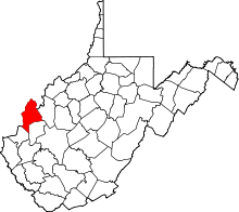
| County | Mason |
| Elevation | 574 ft (175 m) |
| Time zone | UTC-5 (Eastern (EST)) |
| • Summer (DST) | UTC-4 (EDT) |
| Area code(s) | 304 & 681 |
| GNIS feature ID | 1554151[1] |
Clifton is an unincorporated community in Mason County, West Virginia, United States. Clifton is located on the east bank of the Ohio River along West Virginia Route 62, 1.5 miles (2.4 km) south of Mason; Middleport, Ohio lies across the river.[2] Clifton had a post office, which closed on May 24, 1997.[3]
The community was named for the cliffs near the original town site.[4]
References
- ↑ U.S. Geological Survey Geographic Names Information System: Clifton, West Virginia
- ↑ Mason County, West Virginia General Highway Map (PDF) (Map). West Virginia Department of Transportation. 2011. p. 1. Retrieved October 12, 2011.
- ↑ "Postmaster Finder - Post Offices by ZIP Code". United States Postal Service. Retrieved October 12, 2011.
- ↑ Kenny, Hamill (1945). West Virginia Place Names: Their Origin and Meaning, Including the Nomenclature of the Streams and Mountains. Piedmont, WV: The Place Name Press. p. 176.
This article is issued from
Wikipedia.
The text is licensed under Creative Commons - Attribution - Sharealike.
Additional terms may apply for the media files.