Wessenden Valley
Coordinates: 53°35′10″N 1°55′44″W / 53.586°N 1.929°W
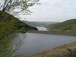
The Wessenden Valley is a moorland valley nestled amidst the Dark Peak, immediately south of the large village of Marsden in the English county of West Yorkshire.[1] The valley was formed by retreating glaciers at the end of the last ice age, and continues to be cut by the Wessenden Brook, a tributary of the River Colne with a catchment area of 6.28 square miles (16.27 km2).[2]
The valley is occupied by four reservoirs, namely (from the top) Wessenden Head, Wessenden, Blakeley and Butterley reservoirs,[3] the last being the largest. The Kirklees Way and Pennine Way long-distance footpaths both follow the valley.[4] The upper part of the valley near Wessenden Head is managed by the National Trust as part of their 5,000 acres (2,000 ha) Marsden Moor Estate.[5]
The reservoir at Butterley had a spillway which was a Grade II Listed structure, the only one of its kind in England;[6] however, Yorkshire Water has now renovated it using concrete after winning a case on appeal.
The name Wessenden derives from Old English and means the 'valley with rock suitable for whetstones'.[7]
References
- ↑ "OL21" (Map). South Pennines (A2 ed.). 1:25,000. Explorer Map. Ordnance Survey. 2008. ISBN 978-0-319-24012-0.
- ↑ "Wessenden Brook from Butterly Reservoir[sic] to River Coln[sic]". Environment Agency. Retrieved 21 December 2016.
- ↑ "Save Butterley Spillway". spillway.co.uk. Retrieved 21 December 2016.
- ↑ "110" (Map). Sheffield & Huddersfield (C1 ed.). 1:50,000. Landranger. Ordnance Survey. 2014. ISBN 978-0-319-22840-1.
- ↑ "Marsden Moor Overview". National Trust. Retrieved 21 December 2016.
- ↑ Robinson, Andrew (9 January 2014). "Campaigners win battle to save unique Butterley Reservoir in Huddersfield". The Yorkshire Post. Retrieved 21 December 2016.
- ↑ Smith, A H (1961). The place-names of the West Riding of Yorkshire. Part 2, Osgoldcross and Agbrigg wapentakes. Cambridge: Cambridge University Press. p. 277. OCLC 181782059.