West Lincoln, Ontario
| West Lincoln | |
|---|---|
| Township (lower-tier) | |
| Township of West Lincoln | |
| Motto(s): Industry, Progress, Agriculture | |
 | |
 West Lincoln | |
| Coordinates: 43°04′N 79°34′W / 43.067°N 79.567°WCoordinates: 43°04′N 79°34′W / 43.067°N 79.567°W | |
| Country |
|
| Province |
|
| Region | Niagara |
| Government | |
| • Mayor | Douglas Joyner |
| • Federal riding | Niagara West—Glanbrook |
| • Prov. riding | Niagara West—Glanbrook |
| Area[1] | |
| • Land | 387.81 km2 (149.73 sq mi) |
| Elevation | 181 m (594 ft) |
| Population (2016)[1] | |
| • Total | 14,500 |
| • Density | 37.4/km2 (97/sq mi) |
| Time zone | UTC-5 (EST) |
| • Summer (DST) | UTC-4 (EDT) |
| Postal Code | L0R |
| Area code(s) | 905, 289, 365 |
| Website | www.westlincoln.ca |
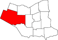
West Lincoln is a township in the Niagara Region of Ontario, Canada. Main urban areas are located along the former provincial Highway 20. The administrative centre of West Lincoln is the community of Smithville, situated halfway between Hamilton and Pelham.
Communities
The township comprises the communities of Abingdon, Allens Corner, Attercliffe, Basingstoke, Bismark, Boyle, Caistor Centre, Caistorville, Elcho, Fulton, Grassie, Kimbo, Port Davidson, Rosedene, Silverdale, Smithville, St. Anns, Vaughan, Warner, Wellandport, Wilcox Corners and Winslow.
Business
Retail establishments in Smithville are congregated amongst two major nodes: the downtown core, and the Village Square Mall.
Smithville also has a Farmers Market that runs every Saturday morning in the summer. The market features a carefully selected variety of vendors showcasing local produce, preserves, meat, honey, flowers and baking.
Demographics
According to the Canada 2016 Census:[1]
- Population: 14,500
- % Change (2011–2016): 4.8
- Dwellings: 5,054
- Private dwellings occupied by usual residents: 4,967
- Area (km²): 387.81
- Density (persons per km²): 37.4
Population trend:[2]
- Population in 2016: 14,500
- Population in 2011: 13,837
- Population in 2006: 13,167
- Population in 2001: 12,268
- Population in 1996: 11,513
- Population in 1991: 10,864
See also
References
- "West Lincoln". Geographical Names Data Base. Natural Resources Canada. Retrieved 2010-10-09.
- "Topographic Map sheets 30L13, 30L14, 30M3, 30M4". Atlas of Canada. Natural Resources Canada. 2010-02-04. Retrieved 2010-10-09.