Weida, Thuringia
| Weida | ||
|---|---|---|
 | ||
| ||
 Weida Location of Weida within Greiz district 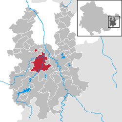 | ||
| Coordinates: 50°46′30″N 12°3′25″E / 50.77500°N 12.05694°ECoordinates: 50°46′30″N 12°3′25″E / 50.77500°N 12.05694°E | ||
| Country | Germany | |
| State | Thuringia | |
| District | Greiz | |
| Government | ||
| • Mayor | Werner Beyer | |
| Area | ||
| • Total | 36.48 km2 (14.09 sq mi) | |
| Elevation | 231 m (758 ft) | |
| Population (2017-12-31)[1] | ||
| • Total | 8,602 | |
| • Density | 240/km2 (610/sq mi) | |
| Time zone | CET/CEST (UTC+1/+2) | |
| Postal codes | 07565–07570 | |
| Dialling codes | 036603 | |
| Vehicle registration | GRZ | |
| Website | www.weida.de | |

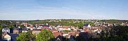
Weida is a town in the district of Greiz, in Thuringia, Germany, situated 12 km south of Gera on the river Weida.
History
Within the German Empire (1871-1918), Weida was part of the Grand Duchy of Saxe-Weimar-Eisenach.
The Eisenhammer Weida is an historic hammer mill.
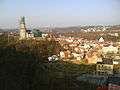 The Osterburg and city of Weida
 The Oschütztal-Viadukt in Weida
References
External links
- Landkreis Greiz (in English) (in German) (in French)
This article is issued from
Wikipedia.
The text is licensed under Creative Commons - Attribution - Sharealike.
Additional terms may apply for the media files.