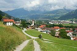
Weerberg
| Weerberg | ||
|---|---|---|
 | ||
| ||
 Weerberg Location within Austria | ||
| Coordinates: 47°17′54″N 11°39′57″E / 47.29833°N 11.66583°ECoordinates: 47°17′54″N 11°39′57″E / 47.29833°N 11.66583°E | ||
| Country | Austria | |
| State | Tyrol | |
| District | Schwaz | |
| Government | ||
| • Mayor | Ferdinand Angerer | |
| Area | ||
| • Total | 55.4 km2 (21.4 sq mi) | |
| Elevation | 882 m (2,894 ft) | |
| Population (1 January 2016)[1] | ||
| • Total | 2,472 | |
| • Density | 45/km2 (120/sq mi) | |
| Time zone | UTC+1 (CET) | |
| • Summer (DST) | UTC+2 (CEST) | |
| Postal code | 6133 | |
| Area code | 05224 | |
| Vehicle registration | SZ | |
| Website | www.weerberg.at | |

Weerberg is a municipality in the Schwaz district in the Austrian state of Tyrol.
Geography
Important peaks in the parish territory are the 2,762 m high Rastkogel and the 2,506 m high Gilfert, both in the Tux Alps.
References
| Wikimedia Commons has media related to Weerberg. |
This article is issued from
Wikipedia.
The text is licensed under Creative Commons - Attribution - Sharealike.
Additional terms may apply for the media files.