Hart im Zillertal
| Hart im Zillertal | ||
|---|---|---|
 | ||
| ||
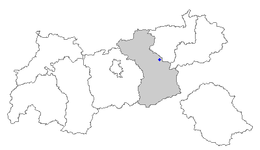
 Hart im Zillertal Location within Austria
Location within Tyrol
| ||
| Coordinates: 47°21′00″N 11°52′00″E / 47.35000°N 11.86667°ECoordinates: 47°21′00″N 11°52′00″E / 47.35000°N 11.86667°E | ||
| Country | Austria | |
| State | Tyrol | |
| District | Schwaz | |
| Government | ||
| • Mayor | Alois Eberharter (ÖVP) | |
| Area | ||
| • Total | 35.54 km2 (13.72 sq mi) | |
| Elevation | 666 m (2,185 ft) | |
| Population (1 January 2016)[1] | ||
| • Total | 1,567 | |
| • Density | 44/km2 (110/sq mi) | |
| Time zone | UTC+1 (CET) | |
| • Summer (DST) | UTC+2 (CEST) | |
| Postal code | 6263 | |
| Area code | 05288 | |
| Vehicle registration | SZ | |

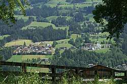
Hart im Zillertal is a municipality in the Schwaz district in the Austrian state of Tyrol.
Geography
Hart lies across from Fügen on the east side of the Ziller.
References
| Wikimedia Commons has media related to Hart im Zillertal. |
This article is issued from
Wikipedia.
The text is licensed under Creative Commons - Attribution - Sharealike.
Additional terms may apply for the media files.