Weeping Water, Nebraska
| Weeping Water, Nebraska | |
|---|---|
| City | |
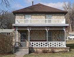 The Heritage House Museum is part of the Weeping Water Historic District, listed in the National Register of Historic Places.[2] | |
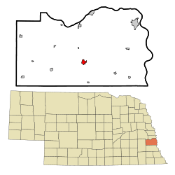 Location of Weeping Water, Nebraska | |
| Coordinates: 40°52′4″N 96°8′21″W / 40.86778°N 96.13917°WCoordinates: 40°52′4″N 96°8′21″W / 40.86778°N 96.13917°W | |
| Country | United States |
| State | Nebraska |
| County | Cass |
| Area[3] | |
| • Total | 0.97 sq mi (2.51 km2) |
| • Land | 0.97 sq mi (2.51 km2) |
| • Water | 0 sq mi (0 km2) |
| Elevation | 1,099 ft (335 m) |
| Population (2010)[4] | |
| • Total | 1,050 |
| • Estimate (2016)[5] | 1,072 |
| • Density | 1,100/sq mi (420/km2) |
| Time zone | UTC-6 (Central (CST)) |
| • Summer (DST) | UTC-5 (CDT) |
| ZIP code | 68463 |
| Area code(s) | 402 |
| FIPS code | 31-52015 |
| GNIS feature ID | 0834529[6] |
| Website |
weepingwaternebraska |
Weeping Water is a city in Cass County, Nebraska, United States. The population was 1,050 at the 2010 census.
History
The Indians named the stream running through Weeping Water Nigahoe, meaning "rustling water", the sound of water running over the low falls. When the French arrived, they confused the name with another Indian word, Nihoage, meaning "water weeping". They gave the stream the French name L'Eau qui Pleure, meaning "water which weeps".[7]
Weeping Water was platted in 1867.[8] Weeping Water incorporated as a village in 1870, and as a city in 1888.[9]
Legend
Debates over the origin of the name have existed since at least the early twentieth century.[10] Regardless of whether the legend originates from Native American sources or simply was created to explain a mistranslation of the Native American name for the area, the legend itself has become an important piece of Nebraska folklore.
According to American folklorist Louise Pound, the first written reference to the legend of Weeping Water is found in the 800-line poem "The Weeping Water" by Orsamus Charles Dake, published in a book of poetry called Nebraska Legends and Other Poems in 1871.[10] Dake's poem is preceded by a preface that "The Weeping Water" was one of two poems which Dake himself "developed."[10][11]
Dake's poem is also preceded by a paragraph summarizing the legend which reads:
The Omaha and Otoe Indians, being at war, chanced to meet on their common hunting ground south of the Platte River in Nebraska. A fierce battle ensued, in which all the male warriors of both tribes being slain, the women and children came upon the battle-field and sat down and wept. From the fountain of their tears arose and ever flows the little stream known as the Ne-hawka or the Weeping Water.[10][11]
The poem itself includes details and dialogue that Dake likely invented, such as the main narrative thrust of the poem, a story of forbidden love between an Otoe man and the daughter of the Omaha chief.[10][11] According to Pound, the words spoken by the characters in the poem are not so much dialogue but rather "[l]ofty speeches of the Homeric and Virgilian type" which Pound attributes to Dake's classical training and tenure as an English professor.[10] Pound suggests that it is most likely, based on the preface and summary he provides with the poem, that Dake took inspiration from a preexisting folktale, though whether the legend was genuinely of Native American origin remains undetermined.[10]
Geography
Weeping Water is located at 40°52′4″N 96°8′21″W / 40.86778°N 96.13917°W (40.867854, -96.139205).[12]
According to the United States Census Bureau, the city has a total area of 0.97 square miles (2.51 km2), all of it land.[3]
Demographics
| Historical population | |||
|---|---|---|---|
| Census | Pop. | %± | |
| 1880 | 317 | — | |
| 1890 | 1,350 | 325.9% | |
| 1900 | 1,156 | −14.4% | |
| 1910 | 1,067 | −7.7% | |
| 1920 | 1,084 | 1.6% | |
| 1930 | 1,029 | −5.1% | |
| 1940 | 1,139 | 10.7% | |
| 1950 | 1,070 | −6.1% | |
| 1960 | 1,048 | −2.1% | |
| 1970 | 1,143 | 9.1% | |
| 1980 | 1,109 | −3.0% | |
| 1990 | 1,008 | −9.1% | |
| 2000 | 1,003 | −0.5% | |
| 2010 | 1,050 | 4.7% | |
| Est. 2016 | 1,072 | [5] | 2.1% |
| U.S. Decennial Census[13] 2012 Estimate[14] | |||
2010 census
As of the census[4] of 2010, there were 1,050 people, 427 households, and 274 families residing in the city. The population density was 1,082.5 inhabitants per square mile (418.0/km2). There were 466 housing units at an average density of 480.4 per square mile (185.5/km2). The racial makeup of the city was 98.8% White, 0.2% African American, 0.1% Native American, 0.1% Asian, 0.1% from other races, and 0.8% from two or more races. Hispanic or Latino of any race were 0.7% of the population.
There were 427 households of which 34.0% had children under the age of 18 living with them, 51.8% were married couples living together, 8.0% had a female householder with no husband present, 4.4% had a male householder with no wife present, and 35.8% were non-families. 29.7% of all households were made up of individuals and 14.3% had someone living alone who was 65 years of age or older. The average household size was 2.46 and the average family size was 3.08.
The median age in the city was 38 years. 26.3% of residents were under the age of 18; 7.2% were between the ages of 18 and 24; 25.4% were from 25 to 44; 28.1% were from 45 to 64; and 13% were 65 years of age or older. The gender makeup of the city was 49.0% male and 51.0% female.
2000 census
As of the census of 2000, there were 1,003 people, 434 households, and 293 families residing in the city. The population density was 1,254.8 people per square mile (483.9/km²). There were 465 housing units at an average density of 529.0 per square mile (204.0/km²). The racial makeup of the city was 99.09% White, 0.09% Native American, 0.09% Pacific Islander, and 0.73% from two or more races. Hispanic or Latino of any race were 0.54% of the population.
There were 434 households out of which 34.1% had children under the age of 18 living with them, 56.7% were married couples living together, 7.4% had a female householder with no husband present, and 32.3% were non-families. 29.3% of all households were made up of individuals and 14.7% had someone living alone who was 65 years of age or older. The average household size was 2.54 and the average family size was 3.15.
In the city, the population was spread out with 27.5% under the age of 18, 8.8% from 18 to 24, 26.8% from 25 to 44, 21.8% from 45 to 64, and 15.1% who were 65 years of age or older. The median age was 37 years. For every 100 females, there were 89.8 males. For every 100 females age 18 and over, there were 90.9 males.
As of 2000 the median income for a household in the city was $42,692, and the median income for a family was $51,250. Males had a median income of $37,656 versus $21,354 for females. The per capita income for the city was $18,674. About 5.1% of families and 7.4% of the population were below the poverty line, including 9.7% of those under age 18 and 7.9% of those age 65 or over.
Culture
Weeping Water is best known for its limestone quarry. Every year, late in June, the town celebrates Limestone Day with a parade, fireworks and games.[15]
References
- ↑ Kolberg, Persijs. "National Register of Historic Places Inventory—Nomination Form". Nebraska State Historical Society. Retrieved April 19, 2012.
- ↑ Kolberg, Persijs. "National Register of Historic Places Inventory—Nomination Form". Nebraska State Historical Society. Retrieved April 19, 2012.
- 1 2 "US Gazetteer files 2010". United States Census Bureau. Retrieved June 24, 2012.
- 1 2 "American FactFinder". United States Census Bureau. Retrieved June 24, 2012.
- 1 2 "Population and Housing Unit Estimates". Retrieved June 9, 2017.
- ↑ "US Board on Geographic Names". United States Geological Survey. October 25, 2007. Retrieved January 31, 2008.
- ↑ Fitzpatrick, Lilian Linder (1925). Nebraska Place-Names, p. 33. Retrieved January 12, 2018.
- ↑ "Weeping Water, Cass County". Center for Advanced Land Management Information Technologies. University of Nebraska. Retrieved August 1, 2014.
- ↑ "Cass County History". Cass County. Retrieved 24 March 2018.
- 1 2 3 4 5 6 7 Pound, Louise (2006). Nebraska Folklore. Lincoln, Nebraska: Bison Books. ISBN 978-0-8032-8788-4.
- 1 2 3 Dake, O. Charles (1871). Nebraska Legends and Poems. New York: Pott & Amery. pp. 11–52.
- ↑ "US Gazetteer files: 2010, 2000, and 1990". United States Census Bureau. February 12, 2011. Retrieved April 23, 2011.
- ↑ United States Census Bureau. "Census of Population and Housing". Retrieved October 16, 2013.
- ↑ "Annual Estimates of the Resident Population: April 1, 2010 to July 1, 2012". Retrieved October 16, 2013.
- ↑ "Visitor Information". City of Weeping Water, Nebraska. Retrieved December 7, 2015.
Municipalities and communities of Cass County, Nebraska, United States | ||
|---|---|---|
| Cities | ||
| Villages | ||
| Unincorporated communities | ||
| Ghost towns | ||
Metropolitan area of Omaha–Council Bluffs | ||||||
|---|---|---|---|---|---|---|
| Primary cities |
|  | ||||
| Cities over 10,000 (per 2010 Census) |
| |||||
| Cities of 5,000 to 10,000 (per 2010 Census) |
| |||||
| Cities of 1,000 to 5,000 (per 2010 Census) |
| |||||
| Census-designated places |
| |||||
| Cities and villages of fewer than 1,000 (per 2010 Census) |
| |||||
| Counties |
| |||||