Wasioja, Minnesota
| Wasioja, Minnesota | |
|---|---|
| Unincorporated community | |
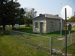 The Civil War recruiting station in Wasioja | |
 Wasioja, Minnesota Location of the community of Wasioja within Wasioja Township, Dodge County  Wasioja, Minnesota Wasioja, Minnesota (the US) | |
| Coordinates: 44°04′49″N 92°49′10″W / 44.08028°N 92.81944°WCoordinates: 44°04′49″N 92°49′10″W / 44.08028°N 92.81944°W | |
| Country | United States |
| State | Minnesota |
| County | Dodge |
| Township | Wasioja Township |
| Elevation | 1,168 ft (356 m) |
| Time zone | UTC-6 (Central (CST)) |
| • Summer (DST) | UTC-5 (CDT) |
| ZIP code | 55927 |
| Area code(s) | 507 |
| GNIS feature ID | 653827[1] |
Wasioja is an unincorporated community in Wasioja Township, Dodge County, Minnesota, United States. The community is located near the junction of Dodge County Roads 9 and 16. The South Branch Middle Fork of the Zumbro River and Dodge Center Creek meet at Wasioja. Nearby places include Dodge Center, Mantorville, and Kasson.
| Historical population | |||
|---|---|---|---|
| Census | Pop. | %± | |
| 1860 | 200 | — | |
| 1870 | 324 | 62.0% | |
| U.S. Decennial Census[2] | |||
History
Wasioja was settled in 1854[3] and platted in 1856.[4] A post office was established at Wasioja in 1856, and remained in operation until 1911.[5] Wasioja is the native Sioux-language name for the Zumbro River.[4] By 1860, the community's population had reached 1,000, its economy driven by limestone quarries, lumber, and agriculture. In 1860 the Minnesota Seminary was opened on the outskirts of town.[3]
The town's fortunes were ruined by three separate events that led to its abandonment by most of its population. Its male population was decimated by the American Civil War, it was bypassed by the railroad in 1866, in favor of a southern route, and it failed to become the county seat of Dodge County. By 1870 the population had declined to 800.[3]
Historic district
Most of the community is contained within the bounds of a historic district, listed on the National Register of Historic Places in 1975. Historically significant buildings include the Wasioja Baptist Church, Wasioja School, a Civil War recruiting station, and the stone Andrew Doig House. Also of historic significance are the ruins of the seminary, now a local park, and the limestone quarries on the outskirts of town.[3]
See also
References
| Wikimedia Commons has media related to Wasioja, Minnesota. |
- ↑ "Wasioja, Minnesota". Geographic Names Information System. United States Geological Survey.
- ↑ United States Census Bureau. "Census of Population and Housing".
- 1 2 3 4 "NRHP nomination for Wasioja Historic District". National Park Service. Retrieved 2017-11-11.
- 1 2 Upham, Warren (1920). Minnesota Geographic Names: Their Origin and Historic Significance. Minnesota Historical Society. p. 174.
- ↑ "Dodge County". Jim Forte Postal History. Retrieved 14 May 2015.
Municipalities and communities of Dodge County, Minnesota, United States | ||
|---|---|---|
| Cities | 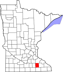 | |
| Townships | ||
| Unincorporated communities | ||
| Ghost town | ||
| Footnotes | ‡This populated place also has portions in an adjacent county or counties | |