Washington State Route 92
| ||||
|---|---|---|---|---|
| Granite Falls Highway | ||||
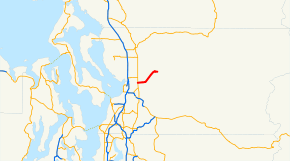 SR 92 highlighted in red. | ||||
| Route information | ||||
| Auxiliary route of SR 9 | ||||
| Defined by RCW 47.17.145 | ||||
| Maintained by WSDOT | ||||
| Length | 9.16 mi[1] (14.74 km) | |||
| Existed | 1964[2]–present | |||
| Major junctions | ||||
| West end |
| |||
| East end | Mountain Loop Highway in Granite Falls | |||
| Location | ||||
| Counties | Snohomish | |||
| Highway system | ||||
| ||||

State Route 92 (SR 92) is a short state highway entirely within Snohomish County, Washington, United States. The nine-mile (14.5 km) highway connects SR 9 in Lake Stevens to the Mountain Loop Highway in Granite Falls.
SR 92 follows the general route of the Monte Cristo and Everett Railroad, which was completed in 1894 and later paralleled by a local road. The highway to Granite Falls was transferred to the state government in 1937 and designated as part of Secondary State Highway 15A (SSH 15A), which continued southwesterly to the Hewitt Avenue Trestle. During the 1964 state highway renumbering, SSH 15A was split between SR 204 and SR 92, the latter of which was moved to a new highway bypassing downtown Lake Stevens in the 1960s.
Recently, the Washington State Department of Transportation (WSDOT) has completed small projects to improve SR 92, including two roundabouts within the first two miles of the highway's western terminus and a roundabout/truck bypass of Granite Falls.
Route description
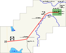
State Route 92 (SR 92) begins at an intersection with SR 9 in Lake Stevens city limits.[1] From the intersection, the roadway forms the northern city limits of Lake Stevens until the Centennial Trail underpass and trailhead.[3][4] From the trail, the road turns northeast at the North Machias Road intersection and enters Lochsloy, where SR 92 starts to parallel the Pilchuck River, which it does to Granite Falls. After leaving Lochsloy, the highway intersects Getchell Road, which travels west to Marysville. From the junction, the road continues northeast into Granite Falls, becoming West Stanley Street and ending at the Mountain Loop Highway.[5][6] In 2007, the western terminus at SR 9 had a daily average of 15,000 motorists, making the intersection the busiest on the highway.[7] The roadway's busiest segment in 1970 was the Granite Falls city limits and the eastern terminus, with a daily average of 3,300 motorists each.[8]
History
.png)
Before SR 92, the Monte Cristo and Everett Railroad used the route, shown on two different maps from 1899 and 1911.[9][10] A highway was built along the route in the late 1910s, connecting to the Pacific Highway west of Lake Stevens.[11] The railroad was replaced with Secondary State Highway 15A (SSH 15A) during the creation of the Primary and secondary state highways in 1937. SSH 15A ran from Primary State Highway 15, later concurrent with U.S. Route 2 (US 2) by 1946,[12] northeast to a brief concurrency with SSH 1A and then northeast once again to Granite Falls.[13] The eastern terminus of SR 92, the Mountain Loop Highway, was completed in December 1941.[14] The Washington State Legislature established the current numbering system during the 1964 highway renumbering and SSH 15A was divided into three new highways, SR 204, SR 9 and SR 92.[2][15] By 1966, SR 9 between Lake Stevens and Arlington was not complete as was SR 92 between the current western terminus and North Machias Road.[16]
The Washington State Department of Transportation (WSDOT) has been improving the roadway since 2005. The first project was completed in October 2005 and replaced a culvert on Stevens Creek with a bridge,[17] located between Lake Road and 99th Avenue,[18] 0.46 miles (0.74 km) east of the SR 9 intersection.[1] A second project completed in September 2006 widened the highway and improved intersections between SR 9 and 84th Street (Getchell Road).[19][20] In 2007, a road was proposed to run from 44th Street Northeast in Marysville to SR 92's western terminus and was later canceled.[21][22] A third project added guardrails on US 2 and SR 92 west of Granite Falls.[23][24] A truck bypass of Granite Falls and SR 92 has been completed; the 2.1-mile (3.4 km) long route runs through Indian camps, where artifacts have been uncovered. Three roundabouts were installed on the bypass: at the SR 92, 100th Street and Jordan Road intersections, which decrease heavy vehicle traffic through Granite Falls.[25][26][27] The roundabout connecting the alternate route to SR 92 opened in May 2010 and was transferred to the state government in 2011.[28][29]
Major intersections
The entire route is in Snohomish County.
| Location | mi[1] | km | Destinations | Notes | |
|---|---|---|---|---|---|
| Lake Stevens | 0.00 | 0.00 | |||
| Granite Falls | 7.26 | 11.68 | Roundabout | ||
| 9.16 | 14.74 | Mountain Loop Highway | |||
| 1.000 mi = 1.609 km; 1.000 km = 0.621 mi | |||||
Spur route
| |
|---|---|
| Location | Granite Falls |
| Length | 0.080 mi[1] (0.13 km) |
| Existed | 2011–present |
SR 92 has a short spur route in western Granite Falls, traveling 0.08 miles (0.13 km) from the Quarry Road roundabout to the city limits of Granite Falls.[1]
References
- 1 2 3 4 5 6 Multimodal Planning Division (January 3, 2018). State Highway Log Planning Report 2017, SR 2 to SR 971 (PDF) (Report). Washington State Department of Transportation. pp. 701–704. Retrieved September 1, 2018.
- 1 2 Washington State Legislature. "RCW 47.17.145: State route No. 92". Retrieved June 19, 2009.
- ↑ Bicycling in Snohomish County, Section 5 (PDF) (Map). Community Transit. 2009. Retrieved June 19, 2009.
- ↑ Snohomish County Centennial Trail (PDF) (Map). Snohomish County. 2009. Retrieved June 19, 2009.
- ↑ Google (June 19, 2009). "State Route 92" (Map). Google Maps. Google. Retrieved June 19, 2009.
- ↑ King, Pierce and Snohomish Counties Street Guide (Map). 1:24,000. Thomas Guide. Cartography by NAVTEQ. Rand McNally. 2008. pp. 358, 377–378. § 358: C7, D6, D7, E5, E6, F4, F5, G3, G4, H4, J4; 377: E4, F4, G4, H4, J3, J4; 378: A3, B1, B2, B3, C1. ISBN 0-528-86671-0.
- ↑ Washington State Department of Transportation (2007). "2007 Annual Traffic Report" (PDF). p. 119. Retrieved June 19, 2009.
- ↑ Washington State Highway Commission, Department of Highways (1970). "Annual Traffic Report, 1970" (PDF). Washington State Department of Transportation. pp. 102–103. Retrieved June 19, 2009.
- ↑ United States Geological Survey (1899). Stillaguamish, 1899 (Map). 1:125,000. Washington 1:125,000 topographic quadrangles. Washington State University. Retrieved June 19, 2009.
- ↑ United States Geological Survey (1911). Mount Vernon, 1911 (Map). 1:125,000. Washington 1:125,000 topographic quadrangles. Washington State University. Retrieved June 19, 2009.
- ↑ Kroll Map Company, 1919
- ↑ Richard Weingroff (January 30, 2008). "U.S. 2: Houlton, Maine, to Everett, Washington". United States Department of Transportation, Federal Highway Administration. Retrieved June 19, 2009.
However, in January 1946, AASHO's U.S. Route Numbering Committee considered a proposal by Idaho and Washington State to extend U.S. 2 to Everett.
- ↑ Washington State Legislature (March 18, 1937). "Chapter 207: Classification of Public Highways". Session Laws of the State of Washington. Session Laws of the State of Washington (1937 ed.). Olympia, Washington: Washington State Legislature. p. 1010. Retrieved June 19, 2009.
(a) Secondary State Highway No. 15A; beginning at a junction with Primary State Highway No. 15 in the vicinity east of Everett, thence in a northeasterly direction by the most feasible route to a junction with Secondary State Highway No. 1A, thence in a northeasterly direction by the most feasible route to Granite Falls.
- ↑ David A. Cameron (March 4, 2008). "A key part of the work to build the scenic Mountain Loop Highway linking Granite Falls to Darrington (Snohomish County) begins on March 23, 1936". HistoryLink. Retrieved June 19, 2009.
- ↑ C. G. Prahl (December 1, 1965). "Identification of State Highways" (PDF). Washington State Highway Commission, Department of Highways. Retrieved June 19, 2009.
- ↑ United States Geological Survey (1966). Victoria, 1966 (Map). 1:250,000. University of Texas at Austin. Retrieved June 19, 2009.
- ↑ Washington State Department of Transportation (2005). "SR 92 – Stevens Creek Culvert Replacement – Complete October 2005". Archived from the original on September 29, 2008. Retrieved June 19, 2009.
- ↑ SR 92 – Stevens Creek Project (Map). Washington State Department of Transportation. 2005. Retrieved June 19, 2009.
- ↑ Washington State Department of Transportation (2006). "SR 92 – SR 9 to 84th Street NE Safety Improvements – Complete September 2006". Archived from the original on September 29, 2008. Retrieved June 19, 2009.
- ↑ SR 92 – SR 9 to 84th Project (Map). Washington State Department of Transportation. 2006. Retrieved June 19, 2009.
- ↑ Sheets, Bill (April 23, 2007). "Road plans upset new residents". The Everett Herald. Retrieved June 19, 2009.
- ↑ Sheets, Bill (June 4, 2007). "Marysville will rethink new road project". The Everett Herald. Retrieved June 19, 2009.
- ↑ Washington State Department of Transportation (2008). "US 2 – SR 92 – Roadside Safety Improvement – Complete July 2008". Retrieved June 19, 2009.
- ↑ US 2 – SR 92 – Roadside Safety Improvement (Map). Washington State Department of Transportation. 2008. Retrieved June 19, 2009.
- ↑ Sheets, Bill (February 25, 2007). "Way cleared for truck route". The Everett Herald. Retrieved June 19, 2009.
- ↑ Sheets, Bill (March 15, 2008). "Granite Falls bypass work set". The Everett Herald. Retrieved June 19, 2009.
- ↑ Judy Stanley (March 15, 2008). Granite Falls bypass work set – Alternate Truck Route (Map). The Everett Herald. Retrieved June 19, 2009.
- ↑ Sheets, Bill (May 20, 2010). "Highway 92 roundabout near Granite Falls opens". The Everett Herald. Retrieved July 5, 2018.
- ↑ http://snohomish.granicus.com/MetaViewer.php?view_id=2&clip_id=2078&meta_id=124502
External links
Route map: