Washington State Route 310
| ||||
|---|---|---|---|---|
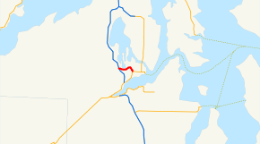 SR 310 is highlighted in red. | ||||
| Route information | ||||
| Auxiliary route of SR 3 | ||||
| Defined by RCW 47.17.569 | ||||
| Maintained by WSDOT | ||||
| Length | 1.84 mi[1] (2.96 km) | |||
| Existed | 1991[2]–present | |||
| Major junctions | ||||
| West end |
| |||
| East end |
| |||
| Location | ||||
| Counties | Kitsap | |||
| Highway system | ||||
| ||||

State Route 310 (SR 310) is a 1.84-mile-long (2.96 km) state highway in the U.S. state of Washington, serving the city of Bremerton in Kitsap County. The highway travels east within Bremerton from an interchange with SR 3 to an intersection with SR 304 as Kitsap Way and Callow Avenue. SR 310 was established in 1991, following the former alignment of SR 3 on city streets in Bremerton before the construction of its current freeway in the 1960s and 1970s. The highway was codified in 1915 as State Road 21 in 1915 and Primary State Highway 21 (PSH 21) in 1937 before becoming SR 3 during the 1964 highway renumbering.
Route description
SR 310 begins at a diamond interchange with the SR 3 in Bremerton and travels east as Kitsap Way, passing south of Oyster Bay.[3][4][5] The highway briefly travels northeast, passing Forest Ridge Park,[6] before turning southward onto 6th Street and Callow Avenue, ending at an intersection with SR 304 as it turns east onto Burwell Street.[1][7]
Every year, the Washington State Department of Transportation (WSDOT) conducts a series of surveys on its highways in the state to measure traffic volume. This is expressed in terms of average annual daily traffic (AADT), which is a measure of traffic volume for any average day of the year. In 2011, WSDOT calculated that between 8,100 and 38,000 vehicles per day used the highway.[8] SR 310 is designated as part of the National Highway System,[9] a system of roads that are important to the nation's economy, defense and mobility.[10] WSDOT has also designated SR 310 as a Highway of Statewide Significance, which is critical to connecting major communities in the state.[11][12]
History
SR 310 was established in 1991 as a connector from SR 304 in Bremerton to the SR 3 freeway,[2] following the alignment of SR 3 in Bremerton prior to the construction of its bypass of Bremerton in the 1970s.[13] The highway was first codified into the state highway system in 1915 as part of State Road 21 and became PSH 21 in 1937.[14][15][16] SR 3 was created during the 1964 highway renumbering, following the route of PSH 21 from Shelton to Port Gamble, and traveled along Callow Avenue and Kitsap Way within Bremerton.[17][18] Work began on a freeway bypass of Bremerton in the 1960s, with the first section opening in February 1968 and SR 3 being re-aligned onto it after 1970.[19][20] After the Ohio-class submarines were commissioned by the United States Navy and Naval Base Kitsap was selected to house them in 1977, a $36.9 million investment in local highways was spent to expand the SR 3 freeway and build a bypass of Silverdale for SR 303.[13] No major revisions to the route of SR 310 have occurred since it was established in 1991,[21] however the City of Bremerton rejected a proposal to repave Kitsap Way in 1997.[22]
Major intersections
The entire highway is in Bremerton, Kitsap County.
| mi[1] | km | Destinations | Notes | ||
|---|---|---|---|---|---|
| 0.00– 0.05 | 0.00– 0.080 | Interchange | |||
| 1.84 | 2.96 | ||||
| 1.000 mi = 1.609 km; 1.000 km = 0.621 mi | |||||
References
- 1 2 3 Staff (2012), State Highway Log: Planning Report 2011, SR 2 to SR 971 (PDF), Washington State Department of Transportation, pp. 1370&ndash, 1372, retrieved February 3, 2013
- 1 2 "47.17.569: State route No. 310", Revised Code of Washington, Washington State Legislature, 1991, retrieved February 3, 2013
- ↑ SR 3: Junction SR 310/Kitsap Way (PDF), Washington State Department of Transportation, September 28, 2001, retrieved February 3, 2013
- ↑ "Feature Detail Report for: Bremerton", Geographic Names Information System, United States Geological Survey, September 10, 1979, retrieved February 3, 2013
- ↑ "Feature Detail Report for: Oyster Bay", Geographic Names Information System, United States Geological Survey, September 10, 1979, retrieved February 3, 2013
- ↑ "Feature Detail Report for: Forest Ridge Park", Geographic Names Information System, United States Geological Survey, September 10, 1979, retrieved February 3, 2013
- ↑ Google (December 12, 2010). "State Route 310" (Map). Google Maps. Google. Retrieved December 12, 2010.
- ↑ Staff (2011), 2011 Annual Traffic Report (PDF), Washington State Department of Transportation, p. 173, retrieved February 3, 2013
- ↑ National Highway System: Seattle, WA (PDF) (Map). Federal Highway Administration. October 1, 2012. Retrieved February 3, 2013.
- ↑ 2010 All State Routes with the NHS Identifier (PDF), 2010, p. 12, retrieved February 3, 2013
- ↑ Transportation Commission List of Highways of Statewide Significance (PDF), Washington State Transportation Commission, July 26, 2009, retrieved February 3, 2013
- ↑ Puget Sound Region: Highways Of Statewide Significance (PDF) (Map). Washington State Department of Transportation. 2009. Retrieved February 3, 2013. }
- 1 2 "35 years ago, Trident subs changed face of Kitsap", Kitsap Sun, Bremerton, Washington, December 29, 2012, retrieved February 3, 2013
|first1=missing|last1=in Authors list (help) - ↑ Washington State Legislature (March 19, 1915), "Chapter 164: Classification of Highways", Session Laws of the State of Washington, Session Laws of the State of Washington (1915 ed.), Olympia, Washington: Washington State Legislature, p. 491, retrieved February 3, 2013,
Section 5901-L. A secondary state highway is established as follows: State road No. 21: This road shall begin at Kingston, thence by the most feasible route through Port Gamble, Poulsbo and Bremerton to a connection with the Olympic Highway between Shelton and Hoodsport in Mason county.
- ↑ Washington State Legislature (March 17, 1937), "Chapter 185: Establishment of Primary State Highways", Session Laws of the State of Washington, Session Laws of the State of Washington (1937 ed.), Olympia, Washington: Washington State Legislature, pp. 941&ndash, 942, retrieved February 3, 2013,
SEC. 19. A primary state highway to be known as Primary State Highway No. 21, or the Kitsap Peninsula Highway, is hereby established according to description as follows: Beginning at Kingston, thence westerly and northerly by the most feasible route by way of Port Gamble, thence southerly by the most feasible route by way of Poulsbo and Bremerton to a junction with Primary State Highway No. 14, west of Port Orchard; also beginning at Keyport, thence in a westerly direction by the most feasible route to a junction with Primary State Highway No. 21, as herein described.
- ↑ Seattle, 1958 (JPG) (Map). 1:250,000. United States Geological Survey. 1958. Retrieved February 3, 2013.
- ↑ Prahl, C. G. (December 1, 1965), Identification of State Highways (PDF), Washington State Highway Commission, Department of Highways, retrieved February 3, 2013
- ↑ Seattle, 1965 (JPG) (Map). 1:250,000. United States Geological Survey. 1965. Retrieved February 3, 2013.
- ↑ Bremerton Freeway Opening First Section, Washington State Highway Commission, Department of Highways, February 8, 1968, retrieved February 3, 2013
- ↑ Staff (1970), Annual Traffic Report, 1970 (PDF), Washington State Highway Commission, Department of Highways, p. 38, retrieved February 3, 2013
- ↑ Washington State Highways, 2011–2012 (PDF) (Map). 1:842,000. Washington State Department of Transportation. 2011. Retrieved February 3, 2013.
- ↑ Barker, Travis (September 18, 1997), "BREMERTON: City rejects bid to repave Kitsap Way", Kitsap Sun, Bremerton, Washington, retrieved February 3, 2013
External links
Route map: