Washington Boulevard (Los Angeles)
| Maintained by | Local jurisdictions |
|---|---|
| West end | Pacific Avenue in Marina del Rey |
| Major junctions |
Sepulveda Boulevard in Culver City La Cienega Boulevard in Culver City Fairfax Avenue in Los Angeles La Brea Avenue in Los Angeles Crenshaw Boulevard in Los Angeles Western Avenue in Los Angeles Normandie Avenue in Los Angeles Vermont Avenue in Los Angeles Figueroa Street in Los Angeles San Pedro Street in Los Angeles Central Avenue in Los Angeles Alameda Street in Los Angeles Soto Street in Los Angeles Atlantic Boulevard in Commerce Telegraph Road in Commerce Garfield Avenue in Commerce |
| East end |
Santa Fe Springs Road, Pickering Avenue, and |
Washington Boulevard is an east-west arterial road in Los Angeles County, California spanning a total of (27.4 miles - 44 km). It starts by the Pacific Ocean just west of Pacific Avenue in Marina del Rey, and ends far to the east in the city of Whittier, on Whittier Boulevard. It is south of Venice Boulevard for most of its length. At Wade Street, Washington Place is formed adjacent and parallel and lasts until just east of Sepulveda Boulevard, where it merges back into Washington Boulevard. Washington merges into Culver Boulevard briefly, but forms back into its own street at Canfield Avenue.
Washington Boulevard, which is four lanes, primarily passes through locations in the mid southern portion of Los Angeles County. The communities to the west include affluent areas such as Marina del Rey and Ladera Heights. Further east it passes between Crestview and Culver City and through Mid City, Arlington Heights, Pico Union, City of Commerce, Montebello, Pico Rivera, Los Nietos and Whittier. Washington Boulevard is the dividing line between the neighborhood Venice in Los Angeles and Marina del Rey.
History
In 1905, when the road was known as Washington Street, it boasted the headquarters of the local horse driving club, for a mile west of Western Avenue. "The road is not of the best," reported the Los Angeles Times, "and automobiles are usurping it . . . but it is the nearest approach to a speedway the reinsmen have, and they therefore make the most of it." Mayor Owen McAleer "has set aside that stretch of the highway to those drivers who delight in vying with each other off the racetrack, and policemen have been given to understand that some latitude is to be allowed horsemen there."[1]
Transportation
Washington Boulevard provides bus service between Venice Beach and West LA Transit Center by Culver City Transit line 1, between West LA Transit Center and Downtown by Metro Local line 35, and east of Downtown by Montebello Transit line 50. A portion of the Metro Blue line runs along Washington Boulevard (serving the Grand/LATTC, San Pedro and Washington stations), from Flower Street to Long Beach Avenue, while the Metro Expo Line serves a rail station near the intersection with National Boulevard.
Major intersections
The entire route is in Los Angeles County. There are no postmiles because the street is maintained by local jurisdictions and not Caltrans.
| Location | Road | Notes |
|---|---|---|
| Los Angeles | Pacific Avenue | Western terminus of Washington Boulevard |
| Also known as Pacific Coast Highway | ||
| Culver City | Sepulveda Boulevard | |
| Culver Boulevard | Overlap with Culver Boulevard for 0.25 mile | |
| La Cienega Boulevard | ||
| Los Angeles | Fairfax Avenue | |
| La Brea Avenue | ||
| Crenshaw Boulevard | ||
| Arlington Avenue | ||
| Western Avenue | ||
| Normandie Avenue | ||
| Vermont Avenue | ||
| Figueroa Street | ||
| San Pedro Street | ||
| Central Avenue | ||
| Alameda Street | ||
| Santa Fe Avenue | ||
| Soto Street | ||
| Commerce | ||
| Atlantic Boulevard/Avenue | ||
| Eastern Avenue | ||
| Northbound entrance and exit via Telegraph Road | ||
| Telegraph Road | ||
| Garfield Avenue | ||
| Montebello | Greenwood Avenue | |
| Pico Rivera | Paramount Boulevard | |
| West Whittier | No control cities listed on I-605; Northbound entrance and exit via Pioneer Boulevard | |
| Pioneer Boulevard | ||
| Santa Fe Springs - West Whittier line | Norwalk Boulevard | |
| Whittier | Lambert Road | Western terminus of Lambert Road; to Chino Hills, California |
| Pickering Avenue, Santa Fe Springs Road, |
Eastern terminus of Washington Boulevard |
Notable landmarks
- Angelus-Rosedale Cemetery
- LA Trade Tech College is located at Grand Avenue near the Blue Line station of the same name.
- The RPM International building (Ray Charles Enterprises) is located on the corner of Westmorland Blvd. and Washington Blvd., which is also dedicated as the "Ray Charles Square".
- The Ray Charles Post Office at La Brea Avenue.[2]
- Government center named after David S. Cunningham, Jr., City Council member, 1973–87
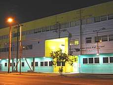
- West Adams Preparatory High School is located on Vermont Avenue and Washington Blvd.[3]
References
- ↑ "Fast Horses His Delight," Los Angeles Times, October 1, 1905, page III-1
- ↑ "Restaurants". Black Enterprise Magazine. 1974.
- ↑ Campus Map