Washington, Iowa
| Washington, Iowa | ||
|---|---|---|
| City | ||
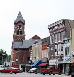 The north side of the Washington Square with the Courthouse in the background. | ||
| ||
| Nickname(s): City of Flowers and Trees | ||
| Motto(s): Onward! To the Salt Mines! | ||
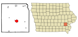 Location of Washington, Iowa | ||
| Coordinates: 41°18′0″N 91°41′21″W / 41.30000°N 91.68917°WCoordinates: 41°18′0″N 91°41′21″W / 41.30000°N 91.68917°W | ||
| Country |
| |
| State |
| |
| County | Washington | |
| Government | ||
| • Mayor | Jaron Rosien | |
| Area[1] | ||
| • Total | 4.92 sq mi (12.74 km2) | |
| • Land | 4.92 sq mi (12.74 km2) | |
| • Water | 0 sq mi (0 km2) | |
| Elevation | 761 ft (232 m) | |
| Population (2010)[2] | ||
| • Total | 7,266 | |
| • Estimate (2016)[3] | 7,424 | |
| • Density | 1,477/sq mi (570.2/km2) | |
| Time zone | UTC-6 (Central (CST)) | |
| • Summer (DST) | UTC-5 (CDT) | |
| ZIP code | 52353 | |
| Area code(s) | 319 | |
| FIPS code | 19-82335 | |
| GNIS feature ID | 0462686 | |
| Website | Official City Website | |
Washington is a city in and the county seat of Washington County, Iowa, United States.[4] It is part of the Iowa City, Iowa Metropolitan Statistical Area. The population was 7,266 at the 2010 census.
History
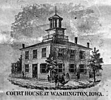
Washington was founded in 1839 as the county seat of the newly established Washington County. In 1854 it became the home of a United Presbyterian College, which was dissolved in 1864. As of 2014, the town has celebrated its 175th anniversary, only 5 years behind the oldest city in Iowa, Dubuque, Iowa.[5]
Geography
Washington is located at 41°18′0″N 91°41′21″W / 41.30000°N 91.68917°W (41.299941, -91.689175).[6]
According to the United States Census Bureau, the city has a total area of 4.92 square miles (12.74 km2), all land.[1]
Demographics
| Historical populations | ||
|---|---|---|
| Year | Pop. | ±% |
| 1870 | 2,575 | — |
| 1880 | 2,949 | +14.5% |
| 1890 | 3,235 | +9.7% |
| 1900 | 4,255 | +31.5% |
| 1910 | 4,380 | +2.9% |
| 1920 | 4,697 | +7.2% |
| 1930 | 4,814 | +2.5% |
| 1940 | 5,227 | +8.6% |
| 1950 | 5,902 | +12.9% |
| 1960 | 6,037 | +2.3% |
| 1970 | 6,317 | +4.6% |
| 1980 | 6,584 | +4.2% |
| 1990 | 7,074 | +7.4% |
| 2000 | 7,047 | −0.4% |
| 2010 | 7,266 | +3.1% |
| 2016 | 7,424 | +2.2% |
| Source:"American FactFinder". United States Census Bureau.
and Iowa Data Center Source: | ||
2010 census
As of the census[2] of 2010, there were 7,266 people, 3,048 households, and 1,861 families residing in the city. The population density was 1,476.8 inhabitants per square mile (570.2/km2). There were 3,301 housing units at an average density of 670.9 per square mile (259.0/km2). The racial makeup of the city was 92.5% White, 1.4% African American, 0.2% Native American, 0.5% Asian, 0.2% Pacific Islander, 2.7% from other races, and 2.6% from two or more races. Hispanic or Latino of any race were 10.7% of the population.
There were 3,048 households of which 29.4% had children under the age of 18 living with them, 46.5% were married couples living together, 10.2% had a female householder with no husband present, 4.3% had a male householder with no wife present, and 38.9% were non-families. 33.8% of all households were made up of individuals and 16.6% had someone living alone who was 65 years of age or older. The average household size was 2.31 and the average family size was 2.93.
The median age in the city was 42.4 years. 23.8% of residents were under the age of 18; 7.1% were between the ages of 18 and 24; 22.1% were from 25 to 44; 25.9% were from 45 to 64; and 21.1% were 65 years of age or older. The gender makeup of the city was 48.1% male and 51.9% female.
2000 census
As of the census[8] of 2000, there were 7,047 people, 2,928 households, and 1,903 families residing in the city. The population density was 1,454.3 people per square mile (561.0/km²). There were 3,132 housing units at an average density of 646.3 per square mile (249.3/km²). The racial makeup of the city was 95.20% White, 0.57% African American, 0.11% Native American, 0.35% Asian, 0.04% Pacific Islander, 2.72% from other races, and 0.99% from two or more races. Hispanic or Latino of any race were 4.71% of the population.
There were 2,928 households out of which 27.7% had children under the age of 18 living with them, 53.8% were married couples living together, 8.6% had a female householder with no husband present, and 35.0% were non-families. 30.9% of all households were made up of individuals and 16.7% had someone living alone who was 65 years of age or older. The average household size was 2.31 and the average family size was 2.88.
Age spread: 22.8% under the age of 18, 7.2% from 18 to 24, 24.9% from 25 to 44, 21.6% from 45 to 64, and 23.5% who were 65 years of age or older. The median age was 42 years. For every 100 females, there were 85.1 males. For every 100 females age 18 and over, there were 82.8 males.
The median income for a household in the city was $36,067, and the median income for a family was $44,497. Males had a median income of $29,961 versus $20,706 for females. The per capita income for the city was $18,145. About 5.4% of families and 9.3% of the population were below the poverty line, including 16.3% of those under age 18 and 5.7% of those age 65 or over.
Government
Washington is governed by a six-member city council headed by a mayor. The mayor and council members are elected for four-year terms. The city council consists of four ward counselors and two At-Large members. The current mayor is Sandra Johnson, and the council members are, Millie Youngquist (At-Large), Russ Zieglowsky (2nd Ward), Brendan DeLong (3rd Ward), Kathryn Salazar (At-Large), Jaron Rosien (4th Ward), and Kerry Janáček (1st Ward).[9]
Notable people
- Charles Almon Dewey, United States federal judge
- Harry W. Bolens, Wisconsin State Senator
- Smith Wildman Brookhart, United States Senator
- Matt Fish, basketball player
- Mike Hennigan, NFL player and coach
- John F. McJunkin, Iowa state senator
- Pierce Knox, blind xylophonist
- Keith Molesworth, basketball player and coach
- Pam Roth, Illinois state representative
- John M. Work, Socialist and newspaper editor
See also
Footnotes
- 1 2 "US Gazetteer files 2010". United States Census Bureau. Archived from the original on 2012-01-24. Retrieved 2012-05-11.
- 1 2 "American FactFinder". United States Census Bureau. Retrieved 2012-05-11.
- ↑ "Population and Housing Unit Estimates". Retrieved June 9, 2017.
- ↑ "Find a County". National Association of Counties. Retrieved 2011-06-07.
- ↑ The History of Washington County, Iowa: Its Cities, Towns, Etc. Union Historical Company. 1880. p. 542.
- ↑ "US Gazetteer files: 2010, 2000, and 1990". United States Census Bureau. 2011-02-12. Retrieved 2011-04-23.
- ↑ "Census of Population and Housing". Census.gov. Retrieved June 4, 2015.
- ↑ "American FactFinder". United States Census Bureau. Retrieved 2008-01-31.
- ↑ http://washingtoniowa.net/index.asp?Type=B_BASIC&SEC={1943ADD0-B592-4AFD-819A-1E150BD6BAEE}
External links
| Wikimedia Commons has media related to Washington, Iowa. |
- Official City Website
- Washington Chamber of Commerce
- Official Facebook Page

Municipalities and communities of Washington County, Iowa, United States | ||
|---|---|---|
| Cities | ||
| Townships | ||
| Unincorporated communities | ||
| Footnotes | ‡This populated place also has portions in an adjacent county or counties | |