Warrenton–Fauquier Airport
| Warrenton–Fauquier Airport | |||||||||||
|---|---|---|---|---|---|---|---|---|---|---|---|
 | |||||||||||
| Summary | |||||||||||
| Airport type | Public | ||||||||||
| Owner | Fauquier County | ||||||||||
| Serves | Warrenton, Virginia | ||||||||||
| Elevation AMSL | 336 ft / 102 m | ||||||||||
| Coordinates | 38°35′11″N 077°42′38″W / 38.58639°N 77.71056°W | ||||||||||
| Map | |||||||||||
 HWY Location of airport in Virginia / United States  HWY HWY (the US) | |||||||||||
| Runways | |||||||||||
| |||||||||||
| Statistics (2007) | |||||||||||
| |||||||||||
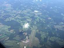
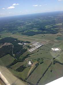
Warrenton–Fauquier Airport (ICAO: KHWY, FAA LID: HWY, formerly W66) is a county-owned, public-use airport located 12 nautical miles (22 km; 14 mi) southeast of the central business district of Warrenton, a town in Fauquier County, Virginia, United States.[1]
Although most U.S. airports use the same three-letter location identifier for the FAA and IATA, this airport is assigned HWY by the FAA but has no designation from the IATA.[2]
Facilities and aircraft
Warrenton–Fauquier Airport covers an area of 407 acres (165 ha) at an elevation of 336 feet (102 m) above mean sea level. It has one runway designated 15/33 with a 5,000 by 100 feet (1,524 m × 30 m) asphalt surface.[1]
For the 12-month period ending June 29, 2007, the airport had 42,184 aircraft operations, an average of 115 per day: 98% general aviation, 1% air taxi and <1% military. At that time there were 119 aircraft based at this airport: 84% single-engine (100), 13% multi-engine, 3% ultralight and 1% helicopter.[1]
See also

- List of airports in Virginia
References
- 1 2 3 4 FAA Airport Master Record for HWY (Form 5010 PDF), effective 2008-04-10
- ↑ Great Circle Mapper: KHWY - Warrenton, Virginia
External links
| Wikimedia Commons has media related to Warrenton–Fauquier Airport. |
- Resources for this airport:
- FAA airport information for HWY
- AirNav airport information for KHWY
- FlightAware airport information and live flight tracker
- NOAA/NWS latest weather observations
- SkyVector aeronautical chart, Terminal Procedures
- FAA Terminal Procedures for HWY, effective October 11, 2018