Waratah West, New South Wales
| Waratah West Newcastle, New South Wales | |||||||||||||||
|---|---|---|---|---|---|---|---|---|---|---|---|---|---|---|---|
|
Waratah West | |||||||||||||||
| Coordinates | 32°54′4″S 151°42′54″E / 32.90111°S 151.71500°ECoordinates: 32°54′4″S 151°42′54″E / 32.90111°S 151.71500°E | ||||||||||||||
| Population | 2,988 (2016 census)[1] | ||||||||||||||
| • Density | 2,130/km2 (5,530/sq mi) | ||||||||||||||
| Postcode(s) | 2298 | ||||||||||||||
| Area | 1.4 km2 (0.5 sq mi) | ||||||||||||||
| Location | 8 km (5 mi) WNW of Newcastle | ||||||||||||||
| LGA(s) | City of Newcastle | ||||||||||||||
| Parish | Newcastle | ||||||||||||||
| State electorate(s) | Wallsend | ||||||||||||||
| Federal Division(s) | Newcastle | ||||||||||||||
| |||||||||||||||
Waratah West is a suburb of Newcastle, New South Wales, Australia, located 8 kilometres (5 mi) from Newcastle's central business district. It is part of the City of Newcastle local government area.
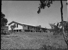
School at Waratah West in 1955
References
- ↑ Australian Bureau of Statistics (27 June 2017). "Waratah West (State Suburb)". 2016 Census QuickStats. Retrieved 9 February 2018.

This article is issued from
Wikipedia.
The text is licensed under Creative Commons - Attribution - Sharealike.
Additional terms may apply for the media files.