Hamilton South, New South Wales
| Hamilton South Newcastle, New South Wales | |||||||||||||||
|---|---|---|---|---|---|---|---|---|---|---|---|---|---|---|---|
| Population | 3,876 (2016 census)[1] | ||||||||||||||
| • Density | 2,280/km2 (5,910/sq mi) | ||||||||||||||
| Postcode(s) | 2303 | ||||||||||||||
| Area | 1.7 km2 (0.7 sq mi) | ||||||||||||||
| Location | 4 km (2 mi) WSW of Newcastle | ||||||||||||||
| LGA(s) | City of Newcastle | ||||||||||||||
| Parish | Newcastle | ||||||||||||||
| State electorate(s) | Newcastle | ||||||||||||||
| Federal Division(s) | Newcastle | ||||||||||||||
| |||||||||||||||
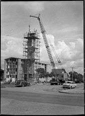
Anglican church under construction in 1957
Hamilton South is a suburb of Newcastle, New South Wales, Australia, located 4 kilometres (2.5 mi) west of Newcastle's central business district.
Hamilton South was part of the Australian Agricultural Company's coal bearing land in inner Newcastle. When mining ceased around 1910 it was decided to create a prestigious estate with an appeal to the higher end of the residential market. The suburb is characterised by late federation style housing. Examples of the design and architecture of the time still remain.
The suburb is serviced by Hamilton South Public School, established in 1933 and contains a number of parks and playing fields, including Learmonth Park, Darling Oval and Henry Park.
References
- ↑ Australian Bureau of Statistics (27 June 2017). "Hamilton South (State Suburb)". 2016 Census QuickStats. Retrieved 9 February 2018.

2. "Hamilton South residents urged to have their say on development" - ABC News Online 23 Oct 2014,
This article is issued from
Wikipedia.
The text is licensed under Creative Commons - Attribution - Sharealike.
Additional terms may apply for the media files.