Wangsa Maju
| Wangsa Maju | |
|---|---|
| Township | |
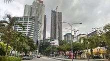
 Aerial view of Wangsa Maju | |
 Wangsa Maju Location within Malaysia | |
| Coordinates: 3°12′2″N 101°44′23″E / 3.20056°N 101.73972°E | |
| Country | Malaysia |
| State | Federal Territory of Kuala Lumpur |
| Constituency | Wangsa Maju |
| Government | |
| • Local Authority | Dewan Bandaraya Kuala Lumpur |
| • Mayor | Tan Sri Hj. Mhd. Amin Nordin bin Abd. Aziz |
| Time zone | UTC+8 (MST) |
| Postcode | 53000-53300 |
| Dialling code | +603-402, +603-403, , +603-410, +603-413, +603-414, +603-416 |
| Police | Wangsa Maju |
Wangsa Maju (Chinese: 旺沙玛珠) is a counstituency in Kuala Lumpur, Malaysia. This area is surrounded by Setapak, Taman Melati and Gombak district in Selangor.
Wangsa Maju in recent years has seen a lot of development, transforming this once traditional Chinese-majority township into a bustling urban areas with more and more high rise buildings being built to cater the increasing population. unbelievable. Although it's a relatively small area compared to its neighbouring Setiawangsa and Gombak, it has a very high concentration of Chinese temples and cultural activities taking place at all time. For example, there are usually over 10 'getai' or mega fest organised for Hungry Ghost Festival celebration in the 7th month of Chinese calendar.
History
The present site of Wangsa Maju was previously occupied by Setapak rubber estates from the 1900s until the 1980s, when the township was formed in 1984. Following the opening of Tunku Abdul Rahman University College (TARC) & Universiti Tunku Abdul Rahman (UTAR), Wangsa Maju has since become a major residential area for the students of TARC & UTAR.
Most residents are from the low to middle income group.[1]
Facilities
- Sections 1 through 10
- Various housing area such as Wangsa Melawati, Desa Setapak, Taman Sri Rampai, Taman Bunga Raya
- Jabatan Pengangkutan Jalan Wangsa Maju (Known for W and V Number plate registration issuance)
- AEON Wangsa Maju (also known as Jusco or Alpha Angle Shopping Centre)
- AEON Big Wangsa Maju (used to be known as Carrefour)
- Wangsa Walk Mall
- Giant Setapak
- Setapak Central – Formerly KL Festival City[2]
- Bangunan ZETRO (currently houses the headquarters of PLKN. Formerly known as Akademi TV3, later became SAL College.)
- Tunku Abdul Rahman University College (TARUC)
- Institute CECE
- VTAR Institute
- Wangsa Maju Teleport
- Wangsa Maju LRT station
- P. Ramlee Memorial
Transport
Public transport
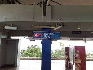
Wangsa Maju is home to two RapidKL LRT stations, KJ3 Wangsa Maju LRT Station and KJ4 Sri Rampai LRT Station.
Car
Wangsa Maju is well served by federal routes and expressways. Jalan Genting Klang ![]()
![]()
![]()
![]()
Wangsa Maju Member of Parliament
The area was carved out of Setiawangsa Parliementary seat (P115) in 2004, resulting an independent Wangsa Maju Parliementary seat (P116). The area was represented by Datuk Yew Teong Loke (MCA) in 2004.[3] In 2008 he lost to Wee Chee Keong (PKR) by merely 151 votes.[4]
The incumbent MP is Datin Paduka Dr Tan Yee Kew of Pakatan Harapan-PKR (former MCA member) who won with majority of 24,238 votes in the 14th general elections, she was the MP for Klang before 2008.[5]
References
- ↑ "A choice place to live with many high-rise and low-cost flats projects - Metro News | The Star Online". www.thestar.com.my. Retrieved 2018-06-08.
- ↑ "Setapak Central". setapakcentral.com.my.
- ↑ "Pilihan Raya Umum Malaysia". pmo.gov.my.
- ↑ "Pilihan Raya Umum Malaysia". pmo.gov.my.
- ↑ "Pilihan Raya Umum Malaysia". pmo.gov.my.
External links
| Parliamentary constituencies | |||||||||||||||||||||||
|---|---|---|---|---|---|---|---|---|---|---|---|---|---|---|---|---|---|---|---|---|---|---|---|
| Suburbs and townships by constituency |
| ||||||||||||||||||||||
Capital: Kuala Lumpur | |
| Topics |
|
| Society |
|
| Parliamentary constituencies | |
| |
Coordinates: 3°11′58″N 101°44′24″E / 3.199495°N 101.7400196°E