Wallace, South Carolina
| Wallace, South Carolina | |
|---|---|
| Unincorporated community & census-designated place | |
 Wallace, South Carolina Location within the state of South Carolina | |
| Coordinates: 34°43′13″N 79°50′29″W / 34.72028°N 79.84139°WCoordinates: 34°43′13″N 79°50′29″W / 34.72028°N 79.84139°W | |
| Country | United States |
| State | South Carolina |
| County | Marlboro |
| Time zone | UTC-5 (Eastern (EST)) |
| • Summer (DST) | UTC-4 (EDT) |
| ZIP codes | 29596 |
| GNIS feature ID | 1251311 |
Wallace is a census-designated place and unincorporated community in northwestern Marlboro County, South Carolina, United States. It lies at the intersection of U.S. Route 1 with SC 9 and SC 177, northwest of the city of Bennettsville, the county seat of Marlboro County.[1] Its elevation is 151&feet (46 m).[2] Although Wallace is unincorporated, it has a post office, with the ZIP code of 29596;[3] the ZCTA for ZIP code 29596 had a population of 2,606 at the 2000 census.[4]
Pegues Place was listed on the National Register of Historic Places in 1971.[5]
References
- ↑ Rand McNally. The Road Atlas '08. Chicago: Rand McNally, 2008, p. 92.
- ↑ U.S. Geological Survey Geographic Names Information System: Wallace, South Carolina
- ↑ Zip Code Lookup
- ↑ "American FactFinder". United States Census Bureau. Retrieved 2008-01-31.
- ↑ National Park Service (2010-07-09). "National Register Information System". National Register of Historic Places. National Park Service.
Municipalities and communities of Marlboro County, South Carolina, United States | ||
|---|---|---|
| City | 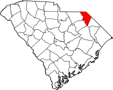 | |
| Towns | ||
| CDP | ||
| Unincorporated communities | ||
| Footnotes | ‡This populated place also has portions in an adjacent county or counties | |
This article is issued from
Wikipedia.
The text is licensed under Creative Commons - Attribution - Sharealike.
Additional terms may apply for the media files.