Waimate
| Waimate | |
|---|---|
| Town | |
 Waimate | |
| Coordinates: 44°44′02″S 171°02′47″E / 44.7340°S 171.0465°ECoordinates: 44°44′02″S 171°02′47″E / 44.7340°S 171.0465°E | |
| Country | New Zealand |
| Island | South Island |
| District | Waimate District |
| Regional Council | Canterbury Regional Council |
| Government | |
| • Mayor | Craig Rowley[1] |
| Population (2006 census) | |
| • Urban area | 2,835 |
| Postcode(s) | 7924 |
| Area code(s) | 03 |
| Website |
www |
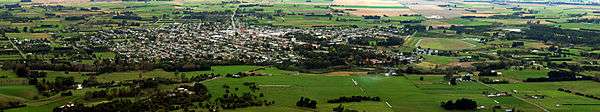
Waimate is a town in Canterbury, New Zealand. It is situated just inland from the eastern coast of the South Island. The town is reached via a short detour west when travelling on State Highway One, the main North/South road. Waimate is 45.7 km south of Timaru, Canterbury's second city, and 20 km north of the Waitaki River, which forms the border between Canterbury and the Otago province to the south.
The population of the Waimate District was recorded in the 2006 census as 7,206 people. The district's area of 3,582.19 square kilometres forms the southern section of the agriculturally rich Canterbury Plains.
Waimate is well known for its population of Bennett's wallabies. These marsupials were introduced from Australia and now live wild in the countryside surrounding the town. It is also recognised for the White Horse Monument which is a silhouette of a white horse that can be seen on the hills behind the town. It commemorates the Clydesdale horses that helped breaking in the land in earlier days. Visitors to the monument's lookout are rewarded with panoramic views of the town and the district's green plains out towards the Pacific Ocean.
History
From 1877 until 1966, Waimate was served by the Waimate Branch, a branch line railway that connected with the Main South Line some seven kilometres east in Studholme. For roughly seventy years ending in 1953, the line ran beyond Waimate to Waihao Downs. When the branch line was closed on 31 March 1966, Waimate became the first major town in New Zealand to lose its railway connection.
Geography
The Waimate District is bounded by the Waitaki River in the south, the Pareora River in the north and the Hakataramea Valley to the west. The district is a very productive agricultural area with a mix of pastoral, cropping, dairy farming, fruit and vegetable growing.
The Waihao River, which starts in the Hunter Hills catchment area runs eastwards on the southern side of the Waimate township joining with the Waimate Creek. They both eventually end up discharging very close to the sea into the Wainono Dead Arm, which then flows into the Wainono Lagoon near Studholme.
Nearby communities
- Glenavy
- Hook
- Hunter
- Ikawai
- Makikihi
- Morven
- Otaio
- Saint Andrews
- Studholme
- Waihao Downs
- Waihaorunga
- Waituna
Economy
Like much of rural New Zealand, Waimate suffered from an economic downturn in the 1980s, with the closure of the dairy factory and a number of sawmills. For the last decade of the 20th century the biggest employers in the district were two furniture manufacturers, a vegetable processing plant and a factory making French fries and other potato products at Makikihi. All but the latter closed within the first few years of the 21st century. However, a newly developed large scale sawmill and the development of a large milk powder factory, coupled with the wealth of dairy farms and the nationwide real estate bubble of 2003-2007, saw a renewed confidence in Waimate.
Education
Further Information: List of schools in Canterbury, New Zealand
- Pre-schools
- Waimate Free Kindergarten
- Waimate Childcare Centre
- Waimate Playcentre
- Primary Schools
- Waimate Main School
- Glenavy School
- Morven School
- Makikihi School[2]
- St Patrick's School (Waimate, NZ)|St Patrick's School
- Waihaorunga School
- Waihao Downs School
- Waimate Centennial School
- Waituna Creek School
- St Andrews School (Waimate, NZ)|St Andrews School
- Secondary Schools
- Waimate High School[3]
Notable people from Waimate
- Eric Batchelor, most highly decorated Commonwealth NCO of World War II.
- Margaret Cruickshank (1873–1918), the second woman to graduate in medicine in New Zealand and the first New Zealand woman to register and practise as a general practitioner. Although not born in Waimate, she spent her professional career there and her achievement is celebrated with a monument of her in the middle of the township.[4]
- Mary Gorman, World War I nurse who died in the sinking of the SS Marquette
- A. M. Hamilton, notable for building the Hamilton Road through Kurdistan and designing the Callender-Hamilton bridge system.
- Major General Howard Kippenberger officer commanding New Zealand forces in North Africa during World War II. Though not born in Waimate his father bought a farm there when he was young and he spent much of his early childhood there.
- Norman Kirk, 29th Prime Minister of New Zealand, 1972–1974.
- Michael Studholme, the first European settler in the region.
Notable places
A statue of Zealandia, a female allegorical representation of New Zealand similar to Great Britain's Britannia, is located just off the main street. Only three Zealandia statues exist in the whole country, the one at Waimate, one at Palmerston in Otago, and another in Auckland. The Waimate and Palmerston statues were erected as Boer War memorials, and the one in Auckland to commemorate troops who fought against Māori in the New Zealand Wars.[5]
St Patrick's Basilica Catholic Church, located on Timaru Rd, was designed in 1908 by Francis Petre and is considered his most original design.[6] St. Augustine's Anglican Church, located on John Street in Waimate, designed in 1872 by Benjamin Mountfort.
Waihao marae, a marae (tribal meeting ground) of Ngāi Tahu and its Te Rūnanga o Waihao branch, is located in the Waimate district.[7] It includes Centennial Memorial Hall, a wharenui (traditional meeting house).[8]
Waimate Museum, located in Shearman St, was designed in 1878 by P.M.F. Burrows. Arcadia Theatre was originally build as Quinn's Arcade in 1906. Waimate White Horse is also located in the town.
Sport
Rugby
- Waimate Rugby Football Club] has teams competing in the South Canterbury rugby competitions. The club is affiliated with the South Canterbury Rugby Football Union.[9]
Golf
- Waimate Golf Club[10]
Events
- March Hare Motorcycle Rally, Annually, first weekend of March
- Waimate 50 Street Race, October
- Waimate Strawberry Fare Annual second weekend in December
- Waimate Shears October
- Waimate Rodeo, Annually 27 December
- Claytons Debating Tournament, Annually in July–August
- Waimate Museum Bookarama, Annually at Labour Weekend
- Waimate Edwardian Heritage Celebrations Annually second weekend in March
Movies and film
- The Waimate Conspiracy (2006)[11] was filmed in Waimate.
Sister cities
References
- ↑ http://www.stuff.co.nz/timaru-herald/news/9276516/Waimate-picks-Craig-Rowley-for-mayor
- ↑ Makikihi School
- ↑ [waimatehigh.school.nz Waimate High School]
- ↑ http://www.teara.govt.nz/en/1966/cruikshanks-margaret-barnet/1
- ↑ "New Zealand Wars memorial statue defaced by anti-colonial activists". stuff.
- ↑ "The Churches of Waimate, South Canterbury". 4 March 2015. Retrieved 4 March 2015.
- ↑ "Te Kāhui Māngai directory". tkm.govt.nz. Te Puni Kōkiri.
- ↑ "Māori Maps". maorimaps.com. Te Potiki National Trust.
- ↑ http://www.sportsground.co.nz/waimaterugby
- ↑ http://www.waimategolf.co.nz/
- ↑ The Waimate Conspiracy on IMDb
External links
| Wikimedia Commons has media related to Waimate. |
- Explore Waimate Waimate District's promotional website.
- An Encyclopedia of New Zealand 1966: Waimate
- Unofficial Waimate site - pictures and links.