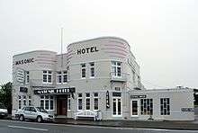
The
art-deco Masonic Hotel in Saint Andrews
Location of Saint Andrews in New Zealand
St Andrews is a small town in the south Canterbury region of New Zealand's South Island. It is located on State Highway 1 five kilometres south of Pareora and 17 kilometres south of Timaru. In 2006 its population was 174. It was linked to Timaru by rail in 1876, and grew after the subdivision of the Pareora Run. It remains a rural service town.[1]
References
- ↑ John Wilson. 'South Canterbury places - Timaru', Te Ara - the Encyclopedia of New Zealand, updated 13-Jul-12, page-6.
Coordinates: 44°31′59″S 171°11′17″E / 44.533°S 171.188°E / -44.533; 171.188
|
---|
|
Hakataramea-Waihaorunga Ward | Hakataramea Sub-Division |
- Cattle Creek
- Hakataramea
- Hakataramea Downs
- Hakataramea Valley
- Kinbrace
- Maungatiro
- Struan
- Te Akatarawa
- Waitangi
|
---|
Waihaorunga Sub-Division |
- DouglasWH
- Elephant HillWH
- IkawaiWH
- Kelceys BushWH
- Pentland Hills
- Waihao DownsWH
- Waihao ForksWH
- WaihaorungaWH
- ArnoDC
- KapuaDC
- KowhatuWH
|
---|
|
---|
Lower Waihao Ward |
- Broad Gully
- Dog Kennel
- Glenavy
- Grays Corner
- Green Hills
- Gum Tree Flat
- Morven
- NukuroaDC
- Pikes Point
- StudholmeDC
- Tawai
- Waikakahi
- WillowbridgeDC
|
---|
Pareora-Otaio-Makikihi Ward |
- Blue Cliffs
- Esk Valley
- Gordons Valley
- Gunns Bush
- Hook
- Hook Bush
- Hunter
- Kohika
- Lyalldale
- Makikihi
- Maungati
- Otaio Gorge
- Otaio
- Saint Andrews
- Southburn
- Springbrook
- Waiariari
- Cup and Saucer Junction
- Riverview
|
---|
Waimate Ward |
- Deep CreekDC
- MaytownDC
- Norton ReserveDC
- UretaneDC
- Waimate
- WaitunaDC
- Te WaimateDC
|
---|
bold - main town; bold & italics - minor town; normal text - locality; italics - minor locality; DC - former populated place of defunct Deep Creek Ward; WH - former populated place of defunct Waihao Ward |