Wadi Qelt
Wadi Qelt (Arabic: وادي القلط; also: Wadi al-Qult, Wadi el-Qult, Wadi Kelt, Wadi Qilt or Wadi Qult), also Nahal Prat (Hebrew: נחל פרת), formerly Naḥal Faran (Pharan), is a valley, riverine gulch or stream (Arabic: وادي wādī, "wadi"; Hebrew: נחל, "nahal") in the West Bank, originating near Jerusalem and running into the Jordan River near Jericho and the Dead Sea.
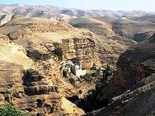
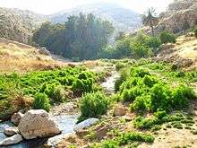
Wadi Qelt is home to a unique variety of flora and fauna. St. George's Monastery and the royal winter palace complex built by the Hasmoneans and Herod the Great are located in the Wadi, which has been identified with the biblical Perath mentioned in Jeremiah 13:5.[1]
History
Ancient history
Wadi Qelt contains monasteries and old Christian locations. Several aqueducts have been found along the stream, the oldest dating to the Hasmonean period (2nd century BC).[2] The aqueducts transported water from three main springs in the valley to Jericho.[3] It was home to the winter palaces of Hasmonean kings and Herod the Great.[4] The Wadi Qelt Synagogue, built as part of the Hasmonean royal winter palace, is believed to be one of the oldest synagogues in the world.[5][6]
Qubur Bani Isra'in are very large Bronze-Age stone structures, which rise from a rocky plateau overlooking Wadi Qelt.[7]
According to tradition, the first monastic settlement of the Judaean desert was established by St Chariton the Confessor towards the end of the 3rd century in upper Wadi Qelt,[8] an area known to the Greek Orthodox as Pharan Valley.
The Monastery of Saint George was founded by John of Thebes around 480 AD, and it became an important spiritual centre in the sixth century under Saint George of Choziba. Hermits living in caves in nearby cliffs would meet in the monastery for a weekly mass and communal meal.[9]
1967 and after
The area was occupied by Israel in 1967.
On December 20, 1968, Israeli lieutenant-Colonel Zvi (Tzvika) Ofer, commander of the elite Haruv unit, former Military Governor of Nablus and recipient of the Israeli medal of valour, was killed in action in Wadi Qelt while pursuing Arab militants who had crossed the Jordan.[10]
Tourism
Israel declared parts of the wadi as a protected area under the name Ein Prat Nature Reserve.[11]
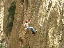
Much of Wadi Qelt is a popular route for Palestinian and Israeli hikers. It is possible to hike all the way from the town of Hizma to Jericho, a journey of 25 kilometres and an 850m descent.[12]
Israeli, Palestinian and foreign hikers use the partially marked paths along the wadi. Palestinians are generally able to visit when coming from Nablus, Ramallah and Jerusalem without having to pass through checkpoints.
Bedouin
The wadi is used by many Bedouin shepherds. Some Bedouin and residents of Jericho are also earning their livelihood near the Monastery of St George, by offering donkey rides to pilgrims and selling them beverages and souvenirs.
See also
- Chariton the Confessor, 3rd-century founder of a lavra-type monastery in Pharan Valley (upper Wadi Qelt)
- Jordan Valley
References
- ↑ "Wadi Qilt". bibleplaces.com.
- ↑ "En Prat Nature Reserve". allaboutjerusalem.com.
- ↑ Gruber, Angela (3 April 2015). "In the occupied West Bank, even hiking is political". +972 mag. Retrieved 2 March 2016.
- ↑ "Jericho - The Winter Palace of King Herod - Jewish Virtual Library". jewishvirtuallibrary.org.
- ↑ Oldest Synagogue Found in Israel, March 29, 1998. Associated Press
- ↑ Israel's Oldest Synagogue, Archaeology, Volume 51 Number 4, July/August 1998, Spencer P.M. Harrington
- ↑ "The Tombs of the Children of Israel". goisrael.com.
- ↑ Skete of Saint Chariton - Fara, Russian Orthodox Ecclesiastical Mission in Jerusalem
- ↑ Palestine & Palestinians. Beit Sahour: Alternative Tourism Group. September 2008. p. 181. ISBN 9950-319-01-3.
- ↑ Teveth, Shabtai (1969/1970) The Cursed Blessing. The story of Israel's occupation of the West Bank. Weidenfeld & Nicolson. SBN 297 00150 7. Translated from Hebrew by Myra Bank. Page 347.
- ↑ "En Prat Nature Reserve". allaboutjerusalem.com.
- ↑ Szepesi, Stefan (2012). Walking Palestine: 25 Journeys Into The West Bank. Oxford: Signal. p. 201. ISBN 978-1-908493-61-3.
External links
| Wikimedia Commons has media related to Wadi Qelt. |
Coordinates: 31°50′40″N 35°24′51″E / 31.844316°N 35.414257°E