Wacousta, Michigan
| Wacousta, Michigan | |
|---|---|
| Census-designated place | |
 Wacousta Location within the state of Michigan | |
| Coordinates: 42°49′40″N 84°42′2″W / 42.82778°N 84.70056°WCoordinates: 42°49′40″N 84°42′2″W / 42.82778°N 84.70056°W | |
| Country | United States |
| State | Michigan |
| County | Clinton County |
| Township | Watertown Charter Township |
| Area | |
| • Total | 9.0 sq mi (23.3 km2) |
| • Land | 8.9 sq mi (23.1 km2) |
| • Water | 0.08 sq mi (0.2 km2) |
| Elevation | 797 ft (243 m) |
| Population (2010) | |
| • Total | 1,440 |
| • Density | 162/sq mi (62.4/km2) |
| Time zone | UTC-5 (Eastern (EST)) |
| • Summer (DST) | UTC-4 (EDT) |
| Area code(s) | 517 |
| FIPS code | 26-82680[1] |
| GNIS feature ID | 1615648[2] |
Wacousta is an unincorporated community and census-designated place (CDP) in Watertown Charter Township, Clinton County in the U.S. state of Michigan. As of the 2010 census it had a population of 1,440.[1]
Geography
Wacousta is located in the western part of Watertown Township and consists of the original unincorporated community of Wacousta at the intersection of E. Herbison Road and S. Wacousta Road, and extending north and west from there for 1 mile (1.6 km) and south and east for 2 miles (3 km). The southern edge of the CDP follows Interstate 96, which has no exits directly serving the community. Downtown Lansing is 12 miles (19 km) to the southeast.
The Wacousta CDP has a total area of 9.0 square miles (23.3 km2), of which 8.9 square miles (23.1 km2) is land and 0.08 square miles (0.2 km2), or 0.87%, is water.[1] The Looking Glass River flows from east to west across the CDP.
References
- 1 2 3 "Geographic Identifiers: 2010 Demographic Profile Data (G001): Wacousta CDP, Michigan". U.S. Census Bureau, American Factfinder. Retrieved October 1, 2014.
- ↑ U.S. Geological Survey Geographic Names Information System: Wacousta, Michigan
Municipalities and communities of Clinton County, Michigan, United States | ||
|---|---|---|
| Cities | 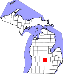 | |
| Villages | ||
| Charter townships | ||
| General law townships | ||
| CDPs | ||
| Footnotes | ‡This populated place also has portions in an adjacent county or counties | |