Elsie, Michigan
| Elsie, Michigan | |
|---|---|
| Village | |
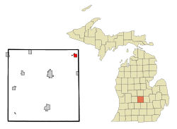 Location of Elsie, Michigan | |
| Coordinates: 43°5′21″N 84°23′26″W / 43.08917°N 84.39056°W | |
| Country | United States |
| State | Michigan |
| County | Clinton |
| Area[1] | |
| • Total | 1.20 sq mi (3.11 km2) |
| • Land | 1.16 sq mi (3.00 km2) |
| • Water | 0.04 sq mi (0.10 km2) |
| Elevation | 732 ft (223 m) |
| Population (2010)[2] | |
| • Total | 966 |
| • Estimate (2016)[3] | 973 |
| • Density | 810/sq mi (310/km2) |
| Time zone | UTC-5 (Eastern (EST)) |
| • Summer (DST) | UTC-4 (EDT) |
| ZIP code | 48831 |
| Area code(s) | 989 |
| FIPS code | 26-25780[4] |
| GNIS feature ID | 0625542[5] |
Elsie is a village in Clinton County in the U.S. state of Michigan. The population was 966 at the 2010 census.
The village consists of two noncontiguous portions within Duplain Township in the northeast portion of Clinton County. It was incorporated in 1885.
History
Elsie was founded in 1857 and platted the same year. It was incorporated in 1885.[6] Elsie is named for Miss Elsie Tillotson, the daughter of an early settler.[7]
Geography
According to the United States Census Bureau, the village has a total area of 1.20 square miles (3.11 km2), of which 1.16 square miles (3.00 km2) is land and 0.04 square miles (0.10 km2) is water.[1]
Demographics
| Historical population | |||
|---|---|---|---|
| Census | Pop. | %± | |
| 1880 | 253 | — | |
| 1890 | 396 | 56.5% | |
| 1900 | 576 | 45.5% | |
| 1910 | 592 | 2.8% | |
| 1920 | 680 | 14.9% | |
| 1930 | 664 | −2.4% | |
| 1940 | 773 | 16.4% | |
| 1950 | 911 | 17.9% | |
| 1960 | 933 | 2.4% | |
| 1970 | 988 | 5.9% | |
| 1980 | 1,022 | 3.4% | |
| 1990 | 957 | −6.4% | |
| 2000 | 1,055 | 10.2% | |
| 2010 | 966 | −8.4% | |
| Est. 2016 | 973 | [3] | 0.7% |
| U.S. Decennial Census[8] | |||
2010 census
As of the census[2] of 2010, there were 966 people, 392 households, and 256 families residing in the village. The population density was 832.8 inhabitants per square mile (321.5/km2). There were 421 housing units at an average density of 362.9 per square mile (140.1/km2). The racial makeup of the village was 97.3% White, 0.4% African American, 0.6% Native American, 0.1% Asian, 0.9% from other races, and 0.6% from two or more races. Hispanic or Latino of any race were 2.4% of the population.
There were 392 households of which 35.5% had children under the age of 18 living with them, 52.0% were married couples living together, 11.0% had a female householder with no husband present, 2.3% had a male householder with no wife present, and 34.7% were non-families. 28.8% of all households were made up of individuals and 13.1% had someone living alone who was 65 years of age or older. The average household size was 2.45 and the average family size was 3.01.
The median age in the village was 39.7 years. 25.5% of residents were under the age of 18; 7.9% were between the ages of 18 and 24; 24.3% were from 25 to 44; 26% were from 45 to 64; and 16.3% were 65 years of age or older. The gender makeup of the village was 48.7% male and 51.3% female.
2000 census
As of the census[4] of 2000, there were 1,055 people, 414 households, and 288 families residing in the village. The population density was 861.9 per square mile (333.9/km²). There were 438 housing units at an average density of 357.8 per square mile (138.6/km²). The racial makeup of the village was 97.82% White, 0.09% African American, 0.19% Native American, 0.09% Asian, 1.42% from other races, and 0.38% from two or more races. Hispanic or Latino of any race were 2.37% of the population.
There were 414 households out of which 32.6% had children under the age of 18 living with them, 55.3% were married couples living together, 11.1% had a female householder with no husband present, and 30.4% were non-families. 26.6% of all households were made up of individuals and 16.4% had someone living alone who was 65 years of age or older. The average household size was 2.53 and the average family size was 3.05.
In the village, the population was spread out with 26.7% under the age of 18, 7.1% from 18 to 24, 26.1% from 25 to 44, 21.9% from 45 to 64, and 18.2% who were 65 years of age or older. The median age was 38 years. For every 100 females, there were 85.4 males. For every 100 females age 18 and over, there were 81.9 males.
The median income for a household in the village was $36,635, and the median income for a family was $43,182. Males had a median income of $35,875 versus $24,375 for females. The per capita income for the village was $15,809. About 8.0% of families and 11.6% of the population were below the poverty line, including 19.3% of those under age 18 and 9.5% of those age 65 or over.
References
- 1 2 "US Gazetteer files 2010". United States Census Bureau. Archived from the original on 2012-01-24. Retrieved 2012-11-25.
- 1 2 "American FactFinder". United States Census Bureau. Retrieved 2012-11-25.
- 1 2 "Population and Housing Unit Estimates". Retrieved June 9, 2017.
- 1 2 "American FactFinder". United States Census Bureau. Archived from the original on 2013-09-11. Retrieved 2008-01-31.
- ↑ "US Board on Geographic Names". United States Geological Survey. 2007-10-25. Retrieved 2008-01-31.
- ↑ Walter Romig, Michigan Place Names, p. 182
- ↑ Gannett, Henry (1905). The Origin of Certain Place Names in the United States. Govt. Print. Off. p. 118.
- ↑ "Census of Population and Housing". Census.gov. Archived from the original on May 12, 2015. Retrieved June 4, 2015.
Municipalities and communities of Clinton County, Michigan, United States | ||
|---|---|---|
| Cities | 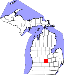 | |
| Villages | ||
| Charter townships | ||
| General law townships | ||
| CDPs | ||
| Footnotes | ‡This populated place also has portions in an adjacent county or counties | |
Coordinates: 43°05′19″N 84°23′13″W / 43.08861°N 84.38694°W