Wachenroth
| Wachenroth | ||
|---|---|---|
| ||
 Wachenroth Location of Wachenroth within Erlangen-Höchstadt district 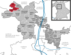 | ||
| Coordinates: 49°45′N 10°43′E / 49.750°N 10.717°ECoordinates: 49°45′N 10°43′E / 49.750°N 10.717°E | ||
| Country | Germany | |
| State | Bavaria | |
| Admin. region | Mittelfranken | |
| District | Erlangen-Höchstadt | |
| Government | ||
| • Mayor | Friedrich Gleitsmann | |
| Area | ||
| • Total | 23.16 km2 (8.94 sq mi) | |
| Elevation | 285 m (935 ft) | |
| Population (2017-12-31)[1] | ||
| • Total | 2,191 | |
| • Density | 95/km2 (250/sq mi) | |
| Time zone | CET/CEST (UTC+1/+2) | |
| Postal codes | 96193 | |
| Dialling codes | 09548 | |
| Vehicle registration | ERH | |
| Website | www.wachenroth.de | |

Wachenroth is a village in the district of Erlangen-Höchstadt, in Bavaria, Germany.
Geography
Wachenroth is situated in the valley of the Reiche Ebrach river, a left tributary of the Regnitz river, at the southern end of the Steigerwald, approx. 20 kilometers northwest of Erlangen.
Division of the town
- Buchfeld
- Warmersdorf
- Weingartsgreuth
- Horbach
- Reumannswind
- Volkersdorf
- Oberalbach
- Unteralbach
- Eckartsmühle
History
- 1008 Earliest known documentary mention
- 1434 Wachenroth receives the market rights
- 1978 Incorporation of Weingartsgreuth with Buchfeld, Horbach and Warmersdorf
Politics
Since 1st Jan 2008 Wachenroth is no more part of the municipal association Verwaltungsgemeinschaft Höchstadt an der Aisch.[2][3]
External links
- Official website (in German)
References
- ↑ "Fortschreibung des Bevölkerungsstandes". Bayerisches Landesamt für Statistik und Datenverarbeitung (in German). September 2018.
- ↑ Zweites Gesetz zur Änderung des Gesetzes über die kommunale Gliederung des Staatsgebiets. Law draft 17th Oct 2007
- ↑ Zweites Gesetz zur Änderung des Gesetzes über die kommunale Gliederung des Staatsgebiets. Decision in the 109th meeting of the Bayerischen Landtags on 15th Nov 2007
Towns and municipalities in Erlangen-Höchstadt | ||
|---|---|---|
This article is issued from
Wikipedia.
The text is licensed under Creative Commons - Attribution - Sharealike.
Additional terms may apply for the media files.