Vrtovin
| Vrtovin | |
|---|---|
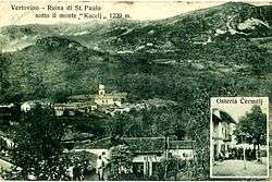 An early 20th-century postcard of Vrtovin | |
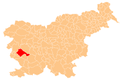
 Vrtovin Location in Slovenia | |
| Coordinates: 45°53′59.68″N 13°48′46.04″E / 45.8999111°N 13.8127889°ECoordinates: 45°53′59.68″N 13°48′46.04″E / 45.8999111°N 13.8127889°E | |
| Country |
|
| Traditional region | Littoral |
| Statistical region | Gorizia |
| Municipality | Ajdovščina |
| Area | |
| • Total | 16.14 km2 (6.23 sq mi) |
| Elevation | 159.3 m (522.6 ft) |
| Population (2002) | |
| • Total | 478 |
| [1] | |
Vrtovin (pronounced [ʋəɾtɔˈʋiːn] or [ʋəɾˈtɔːʋin]; Italian: Vertovino[2]) is a village on the northern edge of the Vipava Valley in the Municipality of Ajdovščina in the Littoral region of Slovenia. It includes several smaller hamlets: Grželi, Čebuli, Fužina, Guli, and Stovška Vas (Slovene: Stovška vas) south of the main village and Krti, Šateji, Subani, Jama, Kocjani, Rebki, Čermeli, Guštini, Fevči, and Lozarji to the north.[3]
The local church is dedicated to the Assumption of Mary and belongs to the Parish of Kamnje.[4]
References
- ↑ Statistical Office of the Republic of Slovenia
- ↑ Vertovino in Mappa della Comune di Vertovino, 1822 Archived 2011-08-07 at the Wayback Machine. - Austrian Cataster
- ↑ Ajdovščina municipal site
- ↑ "Koper Diocese list of churches" (PDF). Archived from the original (PDF) on 2009-03-06. Retrieved 2009-03-06.
External links
| Settlements | Administrative centre: Ajdovščina
|  | ||||
|---|---|---|---|---|---|---|
| Landmarks |
| |||||
| Notable people |
| |||||
| ||||||
This article is issued from
Wikipedia.
The text is licensed under Creative Commons - Attribution - Sharealike.
Additional terms may apply for the media files.