Vrhpolje pri Kamniku
| Vrhpolje pri Kamniku | |
|---|---|
 | |
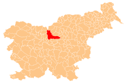
 Vrhpolje pri Kamniku Location in Slovenia | |
| Coordinates: 46°13′48.06″N 14°37′53.11″E / 46.2300167°N 14.6314194°ECoordinates: 46°13′48.06″N 14°37′53.11″E / 46.2300167°N 14.6314194°E | |
| Country |
|
| Traditional region | Upper Carniola |
| Statistical region | Central Slovenia |
| Municipality | Kamnik |
| Area | |
| • Total | 0.94 km2 (0.36 sq mi) |
| Elevation | 392.9 m (1,289.0 ft) |
| Population (2002) | |
| • Total | 664 |
| [1] | |
Vrhpolje pri Kamniku (pronounced [ˈʋəɾxpɔljɛ pɾi ˈkaːmniku]; German: Oberfeld[2]) is a settlement in the Municipality of Kamnik in the Upper Carniola region of Slovenia. Urban expansion has turned it into a single continuous settlement with the neighbouring settlement of Nevlje. The main road from Kamnik into the Tuhinj Valley runs through Vrhpolje.
Name
The name of the settlement was changed from Vrhpolje to Vrhpolje pri Kamniku in 1955.[3] In the past the German name was Oberfeld.[2]
Gallery
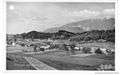 Historical postcard of Vrhpolje pri Kamniku
References
- ↑ Statistical Office of the Republic of Slovenia
- 1 2 Leksikon občin kraljestev in dežel zastopanih v državnem zboru, vol. 6: Kranjsko. 1906. Vienna: C. Kr. Dvorna in Državna Tiskarna, p. 28.
- ↑ Spremembe naselij 1948–95. 1996. Database. Ljubljana: Geografski inštitut ZRC SAZU, DZS.
External links
- Vrhpolje pri Kamniku at Geopedia

This article is issued from
Wikipedia.
The text is licensed under Creative Commons - Attribution - Sharealike.
Additional terms may apply for the media files.