Vomperbach
| Vomperbach | |
|---|---|
 | |
| Country | Tyrol |
| Physical characteristics | |
| Main source | Karwendel mountain range |
| River mouth |
Inn River near Vomp 47°19′27″N 11°40′45″E / 47.3243°N 11.6791°ECoordinates: 47°19′27″N 11°40′45″E / 47.3243°N 11.6791°E |
| Length | 17.2 km (10.7 mi) [1] |
| Basin features | |
| Progression | Inn→ Danube→ Black Sea |
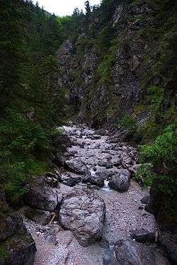
The Vomperbach rises in the Karwendel mountain range, close to the source of the Isar. It flows first from West to East. Above the village of Vomp - which it passes through - it changes its course and flows from North to South into the Inn River. It has a length of 17 kilometers.
Water quality
In the headwaters the brook is covered by detrital and almost invisible. This point is called "Vomper Loch" (=Hole of Vomp). Then it flows through a narrow ravine to Vomp. From the ravine to the mouth the water quality remains constant Grade A and provides the village with drinking water.
References
This article is issued from
Wikipedia.
The text is licensed under Creative Commons - Attribution - Sharealike.
Additional terms may apply for the media files.