Vohemar District
| Vohemar District | |
|---|---|
| District | |
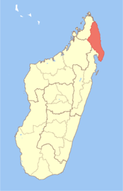
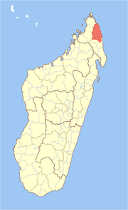 Location in Madagascar | |
| Coordinates: 13°19′S 49°43′E / 13.317°S 49.717°E | |
| Country |
|
| Region | Sava |
| Area | |
| • Total | 8,268.55 km2 (3,192.51 sq mi) |
| Population (2013) | |
| • Total | 255,080 |
| • Density | 31/km2 (80/sq mi) |
| • Ethnicities | Antankarana |
| Time zone | UTC3 (EAT) |
Vohemar District (also Vohimarina District) is a district in northern Madagascar. It is a part of Sava Region and borders the districts of Sambava to the south, Ambilobe to the west and Antsiranana II to the north. The area is 8,268.55 km2 (3,193 sq mi) and the population was estimated to be 255,080 in 2013.[1]
The district is further divided into 19 communes.
References and notes
- ↑ Institutr Nationalde la Statistique, Antananarivo.
Coordinates: 13°19′S 49°43′E / 13.317°S 49.717°E
This article is issued from
Wikipedia.
The text is licensed under Creative Commons - Attribution - Sharealike.
Additional terms may apply for the media files.