Virginia State Route 228
| ||||
|---|---|---|---|---|
 | ||||
| Route information | ||||
| Maintained by VDOT | ||||
| Length | 4.53 mi[1] (7.29 km) | |||
| Existed | 1966–present | |||
| Major junctions | ||||
| South end |
| |||
| North end |
| |||
| Location | ||||
| Counties | Fairfax | |||
| Highway system | ||||
| ||||

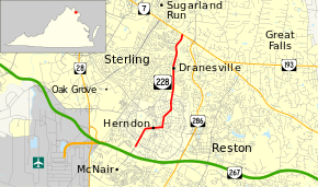
State Route 228 (SR 228) is a primary state highway in the U.S. state of Virginia. The state highway runs 4.53 miles (7.29 km) from SR 657 at the southern town limit of Herndon north to SR 7 near Dranesville. SR 228 is the main north–south highway through Herndon, connecting the town directly with SR 7 and indirectly with SR 267 in northwestern Fairfax County.
Route description
_between_Bennett_Street_and_Old_Hunt_Way_in_Herndon%2C_Fairfax_County%2C_Virginia.jpg)
_at_Crestview_Drive_in_Herndon%2C_Fairfax_County%2C_Virginia.jpg)
SR 228 begins at the southern town limit of Herndon between Parcher Avenue and Herndon Parkway. The roadway continues south into Oak Hill as SR 657 (Centreville Road), which has a diamond interchange with SR 267 (Dulles Toll Road) south of Parcher Avenue. SR 228 heads northeast as Elden Street, which begins as a six-lane divided highway in a commercial area. North of Herndon Parkway, which is a circumferential boulevard within the town of Herndon, the highway becomes a five-lane road with center turn lane. SR 228 intersects SR 606 (Sterling Road) and curves east, reducing to two lanes and passing through a residential area on its way to downtown Herndon. In the center of town, the state highway intersects the Washington & Old Dominion Railroad Trail next to the Herndon Depot Museum. One block east of the rail trail, SR 228 turns north onto Monroe Street; Elden Street continues east as SR 606. The state highway veers northeast onto Park Avenue, then north again onto Dranesville Road, where the highway becomes four lanes. SR 228 intersects the northern leg of Herndon Parkway and becomes a divided highway at the northern town limit next to Herndon High School. The state highway passes several residential subdivisions before reaching its northern terminus at SR 7 (Leesburg Pike) west of Dranesville and just east of the Fairfax–Loudoun county line.[1][2]
Major intersections
The entire route is in Fairfax County.
| Location | mi[1] | km | Destinations | Notes | |
|---|---|---|---|---|---|
| Herndon | 0.00 | 0.00 | Southern town limit of Herndon | ||
| Herndon Parkway - truck route to SR 228 north / SR 606 | |||||
| Herndon Parkway - truck route to SR 228 south / SR 606 | |||||
| Herndon Junction | 4.53 | 7.29 | |||
| 1.000 mi = 1.609 km; 1.000 km = 0.621 mi | |||||
References
- 1 2 3 "2010 Traffic Data". Virginia Department of Transportation. 2010. Retrieved 2011-12-08.
- ↑ Google (2011-12-08). "Virginia State Route 228" (Map). Google Maps. Google. Retrieved 2011-12-08.
External links
| Wikimedia Commons has media related to Virginia State Route 228. |
Route map: