Virginia State Route 214
| ||||
|---|---|---|---|---|
| Stratford Hall Road | ||||
 | ||||
| Route information | ||||
| Maintained by VDOT | ||||
| Length | 2.48 mi[1] (3.99 km) | |||
| Existed | 1933–present | |||
| Tourist routes |
| |||
| Major junctions | ||||
| West end |
| |||
| East end |
| |||
| Location | ||||
| Counties | Westmoreland | |||
| Highway system | ||||
| ||||

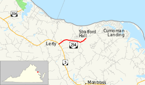
State Route 214 (SR 214) is a primary state highway in the U.S. state of Virginia. Known as Stratford Hall Road, the state highway runs 2.48 miles (3.99 km) from SR 3 at Lerty northeast to SR 609 near Bryant Town in northern Westmoreland County. SR 214 provides access to Stratford Hall, the birthplace of Robert E. Lee.
SR 214 is a Virginia Byway.
Route description
_at_Virginia_State_Route_3_(Kings_Highway)_in_Lerty%2C_Westmoreland_County%2C_Virginia.jpg)
SR 214 begins at an intersection with SR 3 (Kings Highway) at Lerty. The state highway heads east and passes to the south of the Stratford Hall property, which is accessed by Great House Road. At SR 644 (Wild Sally Road), SR 214 veers northeast and reaches its eastern terminus at an arbitrary point east of Stratford Hall. Stratford Hall Road continues northeast as SR 609 through the hamlet of Bryant Town.[1][2]
Major intersections
The entire route is in Westmoreland County.
| Location | mi[1] | km | Destinations | Notes | |
|---|---|---|---|---|---|
| Lerty | 0.00 | 0.00 | |||
| | Stratford Hall | ||||
| | 2.48 | 3.99 | |||
| 1.000 mi = 1.609 km; 1.000 km = 0.621 mi | |||||
References
- 1 2 3 "2010 Traffic Data". Virginia Department of Transportation. 2010. Retrieved 2011-12-05.
- Westmoreland County (PDF)
- ↑ Google (2011-12-05). "Virginia State Route 214" (Map). Google Maps. Google. Retrieved 2011-12-05.
External links
| Wikimedia Commons has media related to Virginia State Route 214. |
Route map:
| < SR 619 | District 6 State Routes 1928–1933 |
SR 621 > |