Vinxtbach
| Vinxtbach | |
|---|---|
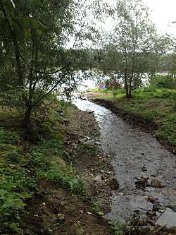 The mouth of the Vinxtbach | |
| Location | Rhineland-Palatinate, Germany |
| Reference no. | DE: 27174 |
| Physical characteristics | |
| Main source |
South-southwest of Schalkenbach-Obervinxt and east of the Adert 397 m above sea level (NHN) 50°28′57″N 7°07′09″E / 50.482378°N 7.119249°ECoordinates: 50°28′57″N 7°07′09″E / 50.482378°N 7.119249°E |
| River mouth |
Near Rheineck Castle between Bad Breisig and Brohl-Lützing into the Rhine 64 m above sea level (NHN) 50°30′05″N 7°18′42″E / 50.501278°N 7.311694°E |
| Length | 19.11 km [1] |
| Basin features | |
| Progression | Rhine→ North Sea |
| Basin size | 45.472 km² [1] |
The Vinxtbach is a stream, around 19 km long, which rises south-southwest of Schalkenbach-Obervinxt and east of the Adert and which discharges into the River Rhine near Rheineck Castle between Bad Breisig and Brohl-Lützing.
The name Vinxt is derived from the Latin term finis, which means "border". Today the Vinxtbach forms a dialect boundary, "Vinxtbach line" (Vinxtbachlinie). North of the Vinxtbach the Ripuarian dialects are spoken, south of it, the Moselle Franconian dialects.
References
External links
| Wikimedia Commons has media related to Vinxtbach. |
This article is issued from
Wikipedia.
The text is licensed under Creative Commons - Attribution - Sharealike.
Additional terms may apply for the media files.