Roald
| Roald | |
|---|---|
| Village | |
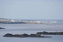 View of Roald (in the background) | |
 Roald Location in Møre og Romsdal  Roald Roald (Norway) | |
| Coordinates: 62°34′56″N 06°07′22″E / 62.58222°N 6.12278°ECoordinates: 62°34′56″N 06°07′22″E / 62.58222°N 6.12278°E | |
| Country | Norway |
| Region | Western Norway |
| County | Møre og Romsdal |
| District | Sunnmøre |
| Municipality | Giske Municipality |
| Area[1] | |
| • Total | 0.68 km2 (0.26 sq mi) |
| Elevation[2] | 5 m (16 ft) |
| Population (2013)[1] | |
| • Total | 808 |
| • Density | 1,188/km2 (3,080/sq mi) |
| Time zone | UTC+01:00 (CET) |
| • Summer (DST) | UTC+02:00 (CEST) |
| Post Code | 6040 Vigra |
Roald is a village in Giske Municipality in Møre og Romsdal county, Norway. The village is located on the northern part of the island Vigra. Roald is about 20 kilometres (12 mi) north of the city centre of Ålesund, connected via two undersea tunnels which opened in 1987 (and will be going through extensive upgrades starting in 2008). Ålesund Airport, Vigra is 2 kilometres (1.2 mi) south of the village of Roald. Vigra Church is located a short distance south of Roald.
The 0.68-square-kilometre (170-acre) village of Roald has a population (2013) of 808, giving the village a population density of 1,188 inhabitants per square kilometre (3,080/sq mi).[1]
The village of Roald was the administrative centre of the old Roald Municipality that existed from 1890 until 1964. The former municipality was later renamed Vigra Municipality. Since 1964, it has been a part of Giske Municipality.[3]
References
- 1 2 3 Statistisk sentralbyrå (1 January 2013). "Urban settlements. Population and area, by municipality".
- ↑ "Roald" (in Norwegian). yr.no. Retrieved 2010-09-28.
- ↑ Jukvam, Dag (1999). "Historisk oversikt over endringer i kommune- og fylkesinndelingen" (PDF) (in Norwegian). Statistisk sentralbyrå.