Victoria Road, Hong Kong
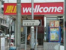
Victoria Road (Chinese: 域多利道; Cantonese Yale: wik6 do1 lei6 dou6) is a main road near the west shore of Hong Kong Island in Hong Kong connecting Kennedy Town and Wah Fu and an alternative connection of Pok Fu Lam Road. It begins north with Belcher's Street in Kennedy Town and goes along Mount Davis, Sandy Bay, Telegraph Bay and Waterfall Bay and reaches in Kellett Bay.
History
The road opened in 1897, the year of Queen Victoria's Diamond Jubilee, celebrating the 60th year of her reign. A stone was laid by Governor Robinson and the road was named Victoria Jubilee Road (域多利慶典道).[1] The road was without any surfacing and only access to Chinese public cemetery in Kellett Bay. In 1903, Hong Kong Government erected a stone at the road in Kennedy Town to mark the boundary of Victoria City. In the 1910s, the road was expanded and renamed to Victoria Road. In the 1960s, for the construction of Wah Fu Estate, the road became a standard road of concrete. In the 2000s, the section near Cyberport was improved.
Notable buildings
- The medical faculty of the University of Hong Kong
- Baguio Villa
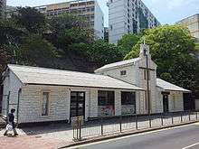
- Former Victoria Road Detention Centre aka. Mount Davis Concentration Camp (摩星嶺集中營), which was used by the Special Branch of the Royal Hong Kong Police Force to hold political prisoners during the 1967 Leftist riots.[2][3] The compound is listed as a Grade III historic building.[4]
See also
References
- 1 2 Yanne, Andrew; Heller, Gillis (2009). Signs of a Colonial Era. Hong Kong University Press. pp. 10, 59. ISBN 9789622099449.
- ↑ "Brief Information on proposed Grade III Items. Item #150" (PDF). Archived from the original (PDF) on 2013-09-22. Retrieved 2012-02-03.
- ↑ Cheung, Gary Ka-wai (1 October 2009). Hong Kong's Watershed: The 1967 Riots. Hong Kong University Press. pp. 84, 93, 205. ISBN 9789622090897.
- ↑ List of the 1,444 Historic Buildings in Building Assessment (as of 24 October 2014)
External links
| Wikimedia Commons has media related to Victoria Road, Hong Kong. |
Coordinates: 22°16′23″N 114°07′32″E / 22.27292°N 114.12562°E