Victoria, Hong Kong
| City of Victoria | |||||||||||||||
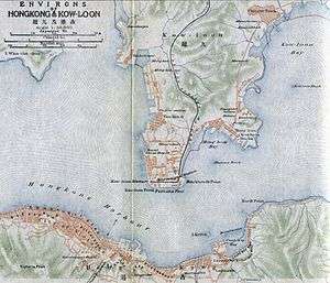 A 1915 map showing Victoria in the south | |||||||||||||||
| Traditional Chinese | 維多利亞城[1] | ||||||||||||||
|---|---|---|---|---|---|---|---|---|---|---|---|---|---|---|---|
| Simplified Chinese | 维多利亚城 | ||||||||||||||
| |||||||||||||||
The City of Victoria,[1] often called Victoria City or simply Victoria, was the de facto capital of Hong Kong during the British colonial period.[2] It was initially named Queenstown but was soon known as Victoria.[3] It was one of the first urban settlements in Hong Kong and almost all government departments still have their head offices located within its limit.
Present-day Central is at the heart of Victoria City. Although the city expanded over much of what is now Kennedy Town, Sheung Wan, and Wan Chai,[4] the name Victoria has been eclipsed by Central in popular usage.[5] However, the name is still used in places such as Victoria Park, Victoria Peak, Victoria Harbour, Victoria Prison, and a number of roads and streets. It is also retained in the names of various organisations such as the Victoria City District of the Hong Kong Scout,[6] and the Victoria Junior Chamber.[7] The name Victoria District Court had been used into the 1980s,[8][9][10][11] when it was moved to the Wanchai Tower and combined with other district courts in the territory.
The boundaries of Victoria City are recorded in the Laws of Hong Kong.[12]
History
In 1857, the British government expanded the scope of Victoria City and divided it into four wans (Chinese: 環; pinyin: huán; Jyutping: waan4; literally: "rings"). The four wans are Sai Wan ("West Ring" in Chinese, present-day Sai Wan, including Kennedy Town, Shek Tong Tsui, and Sai Ying Pun), Sheung Wan ("Upper Ring" in Chinese, present-day Sheung Wan), Choong Wan or Chung Wan ("Central Ring" in Chinese, present-day Central) and Ha Wan ("Lower Ring" in Chinese, present-day Wan Chai). "Sai Wan", "Sheung Wan" and "Choong Wan" retain the same name in Chinese today.
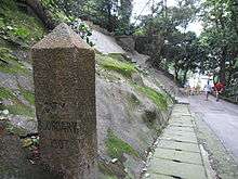
The four wans are further divided into nine yeuks (Chinese: 約; pinyin: yuē; Jyutping: joek3, similar to "district" or "neighbourhood"). The coverage also included parts of East Point and Happy Valley (West of Wong Nai Chung Road on the east side of the racecourse). In 1903, boundary stones were established to mark the city's boundary and six of them are still preserved today. The stones spread from Causeway Bay to Kennedy Town.[13]
In the 1890s, Victoria extended four miles west to east along the coastal strip. Buildings were made of granite and brick. Buses and the new tramway would become the main form of transportation in the area.[14]
The city is centred in present-day Central, and named after Queen Victoria in 1843. It occupies the areas known in modern times as Central, Admiralty, Sheung Wan, Wan Chai, East Point, Shek Tong Tsui, the Mid-levels, the Peak, Happy Valley, Tin Hau, and Kennedy Town, on Hong Kong Island.
Boundaries
The city boundaries are defined in the laws of Hong Kong as follows:[1]
- On the north – The Harbour;
- On the west – A line running due north and south drawn through the north-west angle of Inland Lot No. 1299 and extending southwards a distance of 850 feet from the aforesaid angle;
- On the south – A line running due east from the southern extremity of the western boundary until it meets a contour in the vicinity of the Hill above Belchers 700 feet above principal datum, that is to say, a level 17.833 feet below the bench-mark known as "Rifleman's Bolt", the highest point of a copper bolt set horizontally in the east wall of the Royal Navy Office and Mess Block Naval Dockyard, and thence following the said contour until it meets the eastern boundary;
- On the east – A line following the west side of the Government Pier, Bay View and thence along the west side of Hing Fat Street, then along the north side of Causeway Road to Moreton Terrace. Thence along the west side of Moreton Terrace to the south-east corner of Inland Lot No. 1580 and produced in a straight line for 80 feet, and thence along the north side of Cotton Path and produced until it meets the west side of Wong Nei Chong Road on the east side of Wong Nei Chong Valley and thence to the south-east angle of Inland Lot No. 1364, produced until it meets the southern boundary.
In 1903, the Hong Kong Government erected seven boundary stones for the city, inscribed "City Boundary 1903" at Hatton Road, Pok Fu Lam Road, Bowen Road, Old Peak Road (舊山頂道), Wong Nai Chung Road, Victoria Road/Sai Ning Street (西寧街) and Magazine Gap Road. All remain, except for the one in Magazine Gap Road, which disappeared around mid-June 2007.[15][16][17]
Districts
Also called yeuks.
- Kennedy Town, Hong Kong
- Shektongtsui
- Sai Ying Poon
- Taipingshan – Victoria Peak or The Peak or Mount Austin
- Sheung Wan
- Choong Wan (known in modern times as Central in English)
- Ha Wan (today's Admiralty)
- Wan Chai
- Bowrington (between today's Wan Chai and Causeway Bay)
- Soo Kun Po
- Happy Valley
- Causeway Bay
See also
- History of Hong Kong
- List of buildings, sites and areas in Hong Kong
- List of places named for Queen Victoria in Hong Kong, for a list of places named after Queen Victoria
- Praya
References
- 1 2 3 "Cap. 1 Interpretation and General Clauses Ordinance ─ Schedule 1 Boundaries of the City of Victoria". Hong Kong e-Legislation. Retrieved 19 June 2017.
- ↑ "Hong Kong". Encyclopædia Britannica. Retrieved 13 May 2016.
- ↑ Shelton, Barrie; Karakiewicz, Justyna; Kvan, Thomas (2011). The Making of Hong Kong: From Vertical to Volumetric. Routledge. p. 41. ISBN 113685763X.
- ↑ Wordie, Jason (2002). Streets: Exploring Hong Kong Island. Hong Kong University Press. p. 12. ISBN 962-209-563-1.
- ↑ Tsang, Steve (2004). A Modern History of Hong Kong. I.B. Tauris. p. 17. ISBN 1-84511-419-1.
- ↑ Victoria City District
- ↑ Victoria Junior Chamber
- ↑ Volume 22 Inland Revenue Board of Review decisions
- ↑ CACC497/1986 The Queen v. Chan Ngai Hung
- ↑ CACC186A/1987 The Queen v Currency Brokers (H.K.) Ltd and Robert Lee Flickinger
- ↑ CACC133A/1986 The Queen v. Wai Hin Keung
- ↑ "Cap 1 Sched 1 Boundaries of the City of Victoria (Interpretation and General Clauses Ordinance)". www.blis.gov.hk. Retrieved 2018-03-23.
- ↑ Wordie, Jason (2002)
- ↑ Sanderson, Edgar (1897–1898). The British Empire in the nineteenth century: its progress and expansion at home and abroad. IV. London: Blackie and Son. p. 339. LCCN 02002538. OCLC 11625716.
- ↑ Antiquities and Monuments Office website: "Boundary Stone, City of Victoria"
- ↑ List of boundary stones, with pictures Archived 29 August 2008 at the Wayback Machine. (in Chinese)
- ↑ Apple Daily article about the boundary stones, 19 August 2007 (in Chinese)
External links
| Wikimedia Commons has media related to Victoria City. |
- Boundary of the City of Victoria as defined in Hong Kong Laws, Cap 1 SCHED 1 of Hong Kong Law
- Article on history of Hong Kong (in Chinese)
- Photos of the 1903 boundary stones
- A article on the "four wans and nine yeuks" in Chinese (Adobe PDF format)
- Another article on "four wans and nine yeuks" (in simplified Chinese)
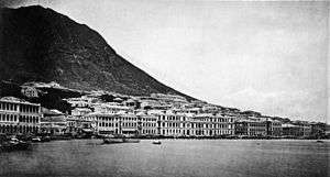
- A photographic panorama of the water-front and city of Victoria, taken sometime after 1906, in Cambridge Digital Library
Coordinates: 22°16′42″N 114°10′28″E / 22.27833°N 114.17444°E