Victoria Peak (British Columbia)
| Victoria Peak | |
|---|---|
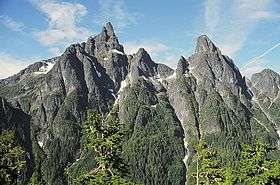 Victoria Peak on the left and Warden Peak on the right | |
| Highest point | |
| Elevation | 2,163 m (7,096 ft) [1] |
| Prominence | 1,849 m (6,066 ft) [1] |
| Listing | |
| Coordinates | 50°03′17″N 126°06′03″W / 50.05472°N 126.10083°WCoordinates: 50°03′17″N 126°06′03″W / 50.05472°N 126.10083°W [1] |
| Geography | |
 Victoria Peak British Columbia | |
| Location | Vancouver Island, British Columbia, Canada |
| Parent range | Sutton Range |
| Topo map | NTS 92L/1 |
| Climbing | |
| First ascent | 1950's Otto Winning, Syd Watts |
Victoria Peak is a mountain located in the Sutton Range of the Vancouver Island Ranges. At 2163 m, it is the third highest peak on Vancouver Island. The mountain is located on the White River valley and has no mountains of comparable elevation nearby. It is accessible as a day trip by logging road and is visible from Campbell River and the Discovery Islands.
See also
References
- 1 2 3 "British Columbia and Alberta: The Ultra-Prominence Page". Peaklist.org. Retrieved 2012-12-25.
Sources
- Philip Stone (2003). Island Alpine, A Guide to the Mountains of Strathcona Park and Vancouver Island. Wild Isle Publications: Heriot Bay, BC. ISBN 0-9680766-5-3.
External links
- "Victoria Peak". Bivouac.com.
- "Victoria Peak". BC Geographical Names.
- "Victoria Peak, British Columbia" on Peakbagger
This article is issued from
Wikipedia.
The text is licensed under Creative Commons - Attribution - Sharealike.
Additional terms may apply for the media files.