| Mountain/Peak | Location | Height (metres) | Prominence (metres) | Range |
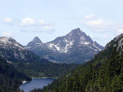
| Golden Hinde | 49°39′46″N 125°44′49″W / 49.662733°N 125.74703°W / 49.662733; -125.74703 (Golden Hinde) | 2,201 | 2,195 | Elk River |
| Elkhorn Mountain | 49°47.4′N 125°49.7′W / 49.7900°N 125.8283°W / 49.7900; -125.8283 (Elkhorn Mountain) | 2,195 | 996 | Elk River |
| Victoria Peak | 50°03.3′N 126°06.0′W / 50.0550°N 126.1000°W / 50.0550; -126.1000 (Victoria Peak) | 2,163 | 1,849 | Sutton |
| Mount Colonel Foster | 49°45.0′N 125°52.1′W / 49.7500°N 125.8683°W / 49.7500; -125.8683 (Mount Colonel Foster) | 2,135 | 864 | Elk River |
| Mount Albert Edward | 49°40.7′N 125°25.9′W / 49.6783°N 125.4317°W / 49.6783; -125.4317 (Mount Albert Edward) | 2,094 | 1,203 | |
| Rambler Peak | 49°44.0′N 125°44.8′W / 49.7333°N 125.7467°W / 49.7333; -125.7467 (Rambler Peak) | 2,092 | 647 | Elk River |
| Mount McBride | 49°43.3′N 125°39.0′W / 49.7217°N 125.6500°W / 49.7217; -125.6500 (Mount McBride) | 2,083 | 918 | |
| Kings Peak | 49°48.7′N 125°50.2′W / 49.8117°N 125.8367°W / 49.8117; -125.8367 (King's Peak) | 2,065 | 328 | Elk River |
| Mount Celeste | 49°34′N 125°24′W / 49.567°N 125.400°W / 49.567; -125.400 (Mount Celeste) | 2,041 | 369 | |
| The Comb | | 2,040 | 0 | |
| Mount Filberg | 49°48′28.1″N 125°43′39.0″W / 49.807806°N 125.727500°W / 49.807806; -125.727500 (Mount Filberg) | 2,035 | 0 | |
| The Red Pillar | 49°31′32.2″N 125°23′21.1″W / 49.525611°N 125.389194°W / 49.525611; -125.389194 (The Red Pillar) | 2,035 | 0 | |
| Mount Cobb | 49°47′23.0″N 125°44′51.0″W / 49.789722°N 125.747500°W / 49.789722; -125.747500 (Mount Cobb) | 2,031 | 0 | |
| The Behinde | 49°39′51.1″N 125°46′14.2″W / 49.664194°N 125.770611°W / 49.664194; -125.770611 (The Behinde) | 1,989 | 0 | |
| Mount Colwell | | 1,989 | 0 | |
| Alexandra Peak | 49°44′17.2″N 125°29′31.9″W / 49.738111°N 125.492194°W / 49.738111; -125.492194 (Alexandra Peak) | 1,983 | 0 | |
| Argus Mountain | 49°32′19.0″N 125°23′11.0″W / 49.538611°N 125.386389°W / 49.538611; -125.386389 (Argus Mountain) | 1,982 | 0 | |
| Mount Harmston | 49°32′56.0″N 125°23′53.9″W / 49.548889°N 125.398306°W / 49.548889; -125.398306 (Mount Harmston) | 1,982 | 0 | |
| Mount Regan | 49°41′06.0″N 125°25′55.0″W / 49.685000°N 125.431944°W / 49.685000; -125.431944 (Mount Regan) | 1,982 | 0 | |
| Iceberg Peak | 49°34′N 125°24′W / 49.567°N 125.400°W / 49.567; -125.400 (Iceberg Peak) | 1,977 | 0 | |
| Warden Peak | 50°03′44.0″N 126°05′46.0″W / 50.062222°N 126.096111°W / 50.062222; -126.096111 (Warden Peak) | 1,970 | 0 | |
| El Piveto Mountain | 49°43.3′N 125°47.2′W / 49.7217°N 125.7867°W / 49.7217; -125.7867 (El Piveto Mountain) | 1,969 | 500 | |
| Mount Rosseau | 49°28′44.0″N 125°30′22.0″W / 49.478889°N 125.506111°W / 49.478889; -125.506111 (Mount Rosseau) | 1,962 | 0 | |
| Comox Glacier | | 1,960 | 0 | |
| Mount Haig-Brown | 49°46′23.0″N 125°44′19.0″W / 49.773056°N 125.738611°W / 49.773056; -125.738611 (Mount Haig-Brown) | 1,947 | 0 | |
| Mount Frink | 49°39′48.0″N 125°24′31.0″W / 49.663333°N 125.408611°W / 49.663333; -125.408611 (Mount Frink) | 1,921 | 0 | |
| Shepherd Ridge | | 1,921 | 0 | |
| Peak 1920 | | 1,920 | 0 | |
| Peak 1909 | | 1,909 | 0 | |
| Mount George V | 49°41.6′N 125°25.9′W / 49.6933°N 125.4317°W / 49.6933; -125.4317 (Mount George V) | 1,884 | 0 | |
| The Misthorns | | 1,880 | 0 | |
| Tzela Mountain | 49°32.0′N 125°25.0′W / 49.5333°N 125.4167°W / 49.5333; -125.4167 (Tzela Mountain) | 1,880 | 0 | |
| Rugged Mountain | 50°01′31″N 126°40′40″W / 50.02528°N 126.67778°W / 50.02528; -126.67778 (Rugged Mountain) | 1,875 | 0 | Haihte |
| Mount Adrian | 49°45′23.0″N 125°31′45.9″W / 49.756389°N 125.529417°W / 49.756389; -125.529417 (Mount Adrian) | 1,870 | 0 | |
| Mount Shoen | | 1,862 | 0 | |
| Big Interior Mountain | 49°27′38.2″N 125°34′26.0″W / 49.460611°N 125.573889°W / 49.460611; -125.573889 (Big Interior Mountain) | 1,863 | 0 | |
| Sutton Peak | 50°02′28.0″N 126°14′07.0″W / 50.041111°N 126.235278°W / 50.041111; -126.235278 (Sutton Peak) | 1,862 | 0 | |
| Mount Septimus | 49°28′50.0″N 125°30′49.0″W / 49.480556°N 125.513611°W / 49.480556; -125.513611 (Mount Septimus) | 1,850 | 0 | |
| Crown Mountain | 49°56.7′N 125°48.8′W / 49.9450°N 125.8133°W / 49.9450; -125.8133 (Crown Mountain) | 1,846 | 1339 | |
| Nine Peaks | 49°25′55.0″N 125°32′57.0″W / 49.431944°N 125.549167°W / 49.431944; -125.549167 (Nine Peaks) | 1,842 | 0 | |
| Syd Watts Peak | | 1,840 | 0 | |
| Siokum Mountain | | 1,840 | 0 | |
| Siocomb Peak | | 1,840 | 0 | |
| Mount Mitchell | 49°41′17.2″N 125°27′47.9″W / 49.688111°N 125.463306°W / 49.688111; -125.463306 (Mount Mitchell) | 1,838 | 0 | |
| Jutland Mountain | 49°42′06.8″N 125°24′51.8″W / 49.701889°N 125.414389°W / 49.701889; -125.414389 (Jutland Mountain) | 1,838 | 0 | |
| Puzzle Mountain | 49°47′26.2″N 125°54′56.2″W / 49.790611°N 125.915611°W / 49.790611; -125.915611 (Puzzle Mountain) | 1,828 | 0 | |
| Maquilla Peak | 50°06′42.1″N 126°20′20.4″W / 50.111694°N 126.339000°W / 50.111694; -126.339000 (Maquilla Peak) | 1,821 | 0 | |
| Mount Arrowsmith | 49°13.4′N 124°35.7′W / 49.2233°N 124.5950°W / 49.2233; -124.5950 (Mount Arrowsmith) | 1,817 | 1,429 | |
| Mount Donner | 49°41′24.0″N 125°53′31.9″W / 49.690000°N 125.892194°W / 49.690000; -125.892194 (Mount Donner) | 1,812 | 0 | |
| Mount Kent-Urquhart | 49°40′35.0″N 125°53′48.8″W / 49.676389°N 125.896889°W / 49.676389; -125.896889 (Mount Kent-Urquhart) | 1,811 | 0 | |
| Mount Myra | 49°32′39.8″N 125°36′22.0″W / 49.544389°N 125.606111°W / 49.544389; -125.606111 (Mount Myra) | 1,810 | 0 | |
| Matchlee Mountain | 49°37′54.8″N 125°58′00.9″W / 49.631889°N 125.966917°W / 49.631889; -125.966917 (Matchlee Mountain) | 1,806 | 0 | |
| Moyeha Mountain | 49°31′00.8″N 125°44′20.0″W / 49.516889°N 125.738889°W / 49.516889; -125.738889 (Moyeha Mountain) | 1,804 | 0 | |
| Mount Cain | 50°13.7′N 126°19.6′W / 50.2283°N 126.3267°W / 50.2283; -126.3267 (Mount Cain) | 1,804 | 0 | |
| Mount Abel | 50°12.714′N 126°19.218′W / 50.211900°N 126.320300°W / 50.211900; -126.320300 (Mount Abel) | 1,800 | 0 | |
| Ptarmigan Pinnacles | | 1,800 | 0 | |
| Morrison Spire | | 1,800 | 0 | |
| Merlon Mountain | 50°02.0′N 126°41.8′W / 50.0333°N 126.6967°W / 50.0333; -126.6967 (Merlon Mountain) | 1,798 | 0 | |
| Mount Laing | 49°49′27.1″N 125°42′24.1″W / 49.824194°N 125.706694°W / 49.824194; -125.706694 (Mount Laing) | 1,798 | 0 | |
| Mount Tom Taylor | 49°28′39.0″N 125°38′16.0″W / 49.477500°N 125.637778°W / 49.477500; -125.637778 (Mount Tom Taylor) | 1,778 | 0 | |
| Mariner Mountain | 49°27.600′N 125°45.783′W / 49.460000°N 125.763050°W / 49.460000; -125.763050 (Mount Mariner) | 1,778 | 0 | |
| Big Den Mountain | 49°53.1′N 125°48.8′W / 49.8850°N 125.8133°W / 49.8850; -125.8133 (Big Den Mountain) | 1,776 | 0 | |
| Peak 5800 | | 1,768 | 0 | |
| Bonanza Peak | 50°19.8′N 126°37.8′W / 50.3300°N 126.6300°W / 50.3300; -126.6300 (Bonanza Peak) | 1,767 | 0 | |
| Hapush Mountain | 50°14.6′N 126°20.0′W / 50.2433°N 126.3333°W / 50.2433; -126.3333 (Mount Hapush) | 1,767 | 0 | |
| Marble Peak | 49°41.7′N 125°36.5′W / 49.6950°N 125.6083°W / 49.6950; -125.6083 (Marble Peak) | 1,767 | 0 | |
| Splendour Mountain | | 1,766 | 0 | |
| Mount Palmerston | 50°24′27.0″N 126°20′13.9″W / 50.407500°N 126.337194°W / 50.407500; -126.337194 (Mount Palmerston) | 1,763 | 0 | |
| Mount Burman | 49°37′26.0″N 125°43′52.0″W / 49.623889°N 125.731111°W / 49.623889; -125.731111 (Mount Burman) | 1,756 | 0 | |
| Mount Judson | 49°56′24.0″N 125°55′18.8″W / 49.940000°N 125.921889°W / 49.940000; -125.921889 (Mount Judson) | 1,747 | 0 | |
| Mount Beadnell | | 1,746 | 0 | |
| Mount Ashwood | 50°18′34.9″N 126°36′13.0″W / 50.309694°N 126.603611°W / 50.309694; -126.603611 (Mount Ashwood) | 1,744 | 0 | |
| Mount Con Reid | 49°44′44.2″N 125°44′12.8″W / 49.745611°N 125.736889°W / 49.745611; -125.736889 (Mount Con Reid) | 1,744 | 0 | |
| Mount Alston | 50°01′00.8″N 126°13′31.1″W / 50.016889°N 126.225306°W / 50.016889; -126.225306 (Mount Alston) | 1,743 | 0 | |
| Watchtower Peak | 50°05′13.9″N 126°13′37.9″W / 50.087194°N 126.227194°W / 50.087194; -126.227194 (Watchtower Peak) | 1,740 | 0 | |
| Mount Russell | 50°23′04.9″N 126°21′47.9″W / 50.384694°N 126.363306°W / 50.384694; -126.363306 (Mount Russell) | 1,740 | 0 | |
| Elk Mountain | | 1,737 | 0 | |
| Ya'ai Peak | 50°02.4′N 126°41.3′W / 50.0400°N 126.6883°W / 50.0400; -126.6883 (Ya'ai Peak) | 1,736 | 0 | |
| Trio Mountain | 49°52′45.8″N 126°00′11.9″W / 49.879389°N 126.003306°W / 49.879389; -126.003306 (Trio Mountain) | 1,732 | 0 | |
| Phillips Ridge | 49°35′48.8″N 125°40′50.2″W / 49.596889°N 125.680611°W / 49.596889; -125.680611 (Phillips Ridge) | 1,732 | 0 | |
| Mount Thelwood | 49°32.3′N 125°44.0′W / 49.5383°N 125.7333°W / 49.5383; -125.7333 (Mount Thelwood) | 1,731 | 0 | |
| Mount Phillips | 49°37′13.1″N 125°34′44.1″W / 49.620306°N 125.578917°W / 49.620306; -125.578917 (Mount Phillips) | 1,723 | 0 | |
| Mount Adam | 50°07′14.2″N 126°13′22.1″W / 50.120611°N 126.222806°W / 50.120611; -126.222806 (Mount Adam) | 1,729 | 0 | |
| Mount DeVoe | 49°41′33.0″N 125°48′24.0″W / 49.692500°N 125.806667°W / 49.692500; -125.806667 (Mount DeVoe) | 1,710 | 0 | |
| Haihte Spire | 50°02′58″N 126°42′0″W / 50.04944°N 126.70000°W / 50.04944; -126.70000 (Haihte Spire) | 1,706 | 0 | |
| Jagged Mountain | 50°16′01.9″N 126°17′28.0″W / 50.267194°N 126.291111°W / 50.267194; -126.291111 (Jagged Mountain) | 1,701 | 0 | |
| Whiltilla Mountain | 50°21′59.0″N 126°42′20.9″W / 50.366389°N 126.705806°W / 50.366389; -126.705806 (Whiltilla Mountain) | 1,693 | 0 | Bonanza Range |
| Popsicle Peak | 49°37′27.9″N 125°54′51.8″W / 49.624417°N 125.914389°W / 49.624417; -125.914389 (Popsicle Peak) | 1,682 | 0 | |
| Mount Bate | 49°53′24.0″N 126°28′24.0″W / 49.890000°N 126.473333°W / 49.890000; -126.473333 (Mount Bate) | 1,680 | 0 | |
| Volcano Peak | | 1,676 | 0 | |
| Mount Abraham | | 1,676 | 0 | |
| South Blades | | 1,676 | 0 | |
| Scimitar Peak | | 1,676 | 0 | |
| Tyee Mountain | 49°58′45.8″N 125°53′39.1″W / 49.979389°N 125.894194°W / 49.979389; -125.894194 (Tyee Mountain) | 1,672 | 0 | |
| Hkusam Mountain | 50°20′05.0″N 125°50′27.0″W / 50.334722°N 125.840833°W / 50.334722; -125.840833 (Hkusam Mountain) | 1,670 | 0 | Prince of Wales |
| Mount Heber | 49°53′48.8″N 125°55′00.8″W / 49.896889°N 125.916889°W / 49.896889; -125.916889 (Mount Heber) | 1,666 | 0 | |
| Crest Mountain | 49°52′18.8″N 125°52′34.0″W / 49.871889°N 125.876111°W / 49.871889; -125.876111 (Crest Mountain) | 1,661 | 0 | |
| Tsitika Mountain | 50°25′36.1″N 126°39′06.1″W / 50.426694°N 126.651694°W / 50.426694; -126.651694 (Tsitika Mountain) | 1,657 | 0 | |
| Mount Juliet | 50°15′29.2″N 126°10′15.9″W / 50.258111°N 126.171083°W / 50.258111; -126.171083 (Mount Juliet) | 1,637 | 0 | |
| Ms. Mountain | 49°39′08″N 125°53′23″W / 49.65222°N 125.88972°W / 49.65222; -125.88972 (Ms. Mountain) | 1,655 | 0 | |
| Mount Nora | 50°09′15.1″N 126°06′50″W / 50.154194°N 126.11389°W / 50.154194; -126.11389 (Mount Nora) | 1,648 | 0 | |
| Mount Sarai | | 1,646 | 0 | |
| Mount Derby | 50°26′17.2″N 126°32′21.8″W / 50.438111°N 126.539389°W / 50.438111; -126.539389 (Mount Derby) | 1,646 | 0 | |
| Klitsa Mountain | 49°15′14.0″N 125°13′53.0″W / 49.253889°N 125.231389°W / 49.253889; -125.231389 (Klitsa Mountain) | 1,642 | 0 | |
| Queen Peak | 50°02′55.0″N 126°03′14.0″W / 50.048611°N 126.053889°W / 50.048611; -126.053889 (Queen Peak) | 1,640 | 0 | |
| Mount Romeo | 50°15′33.8″N 126°12′29.2″W / 50.259389°N 126.208111°W / 50.259389; -126.208111 (Mount Romeo) | 1,637 | 0 | |
| Mount McKelvie | 49°59′17.2″N 126°34′50.9″W / 49.988111°N 126.580806°W / 49.988111; -126.580806 (Mount McKelvie) | 1,630 | 0 | |
| Hyro Peak | | 1,628 | 0 | |
| Eden Mountain | 50°14′11.0″N 126°14′52.1″W / 50.236389°N 126.247806°W / 50.236389; -126.247806 (Eden Mountain) | 1,625 | 0 | |
| Mount Cokely | 49°14′21.8″N 124°35′12.1″W / 49.239389°N 124.586694°W / 49.239389; -124.586694 (Mount Cokely) | 1,616 | 0 | |
| Kokummi Mountain | 50°05′55.0″N 126°08′22.9″W / 50.098611°N 126.139694°W / 50.098611; -126.139694 (Kokummi Mountain) | 1,615 | 0 | Sutton |
| Thumb Peak | | 1,615 | 0 | |
| Mount Moriarty | 49°08.3′N 124°27.1′W / 49.1383°N 124.4517°W / 49.1383; -124.4517 (Mount Moriarty) | 1,610 | 0 | |
| Big Baldy Mountain | 49°45.6′N 126°08.0′W / 49.7600°N 126.1333°W / 49.7600; -126.1333 (Big Baldy Mountain) | 1,610 | 0 | |
| Bancroft Peak | | 1605? | 0 | |
| Waring Peak | | 1,601 | 0 | |
| The Scissors | | 1,597 | 0 | |
| Woss Mountain | 50°03′34.9″N 126°33′37.1″W / 50.059694°N 126.560306°W / 50.059694; -126.560306 (Woss Mountain) | 1,594 | 0 | |
| Mount Washington | 49°45′N 125°18′W / 49.750°N 125.300°W / 49.750; -125.300 (Mount Washington) | 1,585 | 510 | |
| Mount Elliott | 50°17′26.9″N 126°29′39.1″W / 50.290806°N 126.494194°W / 50.290806; -126.494194 (Mount Elliott) | 1,581 | 0 | |
| Zeballos Peak | 50°05′48.0″N 126°46′08.0″W / 50.096667°N 126.768889°W / 50.096667; -126.768889 (Zeballos Peak) | 1,576 | 0 | |
| Mount McQuillan | 49°06′33.8″N 124°36′18.0″W / 49.109389°N 124.605000°W / 49.109389; -124.605000 (Mount McQuillan) | 1,575 | 0 | |
| Malaspina Peak | 49°51.9′N 126°32.1′W / 49.8650°N 126.5350°W / 49.8650; -126.5350 (Malaspina Peak) | 1,573 | 0 | |
| Peak 5150 | | 1,570 | 0 | |
| Nahmint Mountain | 49°12.5′N 125°12.8′W / 49.2083°N 125.2133°W / 49.2083; -125.2133 (Malaspina Peak) | 1,568 | 0 | |
| Mount Peel | | 1,564 | 0 | |
| Mount Joan | 49°24.9′N 124°55.2′W / 49.4150°N 124.9200°W / 49.4150; -124.9200 (Mount Joan) | 1,557 | 0 | Beaufort |
| Mount Grattan | 49°54.4′N 126°29.2′W / 49.9067°N 126.4867°W / 49.9067; -126.4867 (Mount Grattan) | 1,550 | 0 | |
| Mount Flannigan | 49°55.2′N 125°43.9′W / 49.9200°N 125.7317°W / 49.9200; -125.7317 (Mount Flannigan) | 1,550 | 0 | |
| Mount Alava | 49°53.4′N 126°29.8′W / 49.8900°N 126.4967°W / 49.8900; -126.4967 (Mount Alava) | 1,550 | 0 | |
| Pinder Peak | 50°11.7′N 126°55.8′W / 50.1950°N 126.9300°W / 50.1950; -126.9300 (Pinder Peak) | 1,542 | 0 | |
| Mount Whymper | 48°57.1′N 124°09.7′W / 48.9517°N 124.1617°W / 48.9517; -124.1617 (Mount Whymper) | 1,541 | 0 | |
| Abco Mountain | 49°25.5′N 125°51.3′W / 49.4250°N 125.8550°W / 49.4250; -125.8550 (Abco Mountain) | 1,526 | 0 | |
| Peak 5005 | | 1,525 | 0 | |
| Stevens Peak | 49°51.4′N 126°27.4′W / 49.8567°N 126.4567°W / 49.8567; -126.4567 (Stevens Peak) | 1,509 | 0 | |
| Barad-dur | | 1,505 | 0 | |
| Mook Peak | 50°09.2′N 126°51.7′W / 50.1533°N 126.8617°W / 50.1533; -126.8617 (Mook Peak) | 1,505 | 0 | |
| El Capitan Mountain | 48°57.3′N 124°13.2′W / 48.9550°N 124.2200°W / 48.9550; -124.2200 (El Capitan Mountain) | 1,492 | 0 | |
| Mount Service | 48°57.8′N 124°15.1′W / 48.9633°N 124.2517°W / 48.9633; -124.2517 (Mount Service) | 1,490 | 0 | |
| Douglas Peak | 49°07.7′N 124°38.6′W / 49.1283°N 124.6433°W / 49.1283; -124.6433 (Douglas Peak) | 1,490 | 0 | |
| Genesis Mountain | | 1,486 | 0 | |
| Mount Titus | | 1,481 | 0 | |
| Conuma Peak | 49°49.7′N 126°18.6′W / 49.8283°N 126.3100°W / 49.8283; -126.3100 (Conuma Peak) | 1,481 | 0 | |
| Limestone Mountain | 49°05.7′N 124°38.7′W / 49.0950°N 124.6450°W / 49.0950; -124.6450 (Limestone Mountain) | 1,480 | 0 | |
| Adder Peak | 49°14.9′N 125°19.0′W / 49.2483°N 125.3167°W / 49.2483; -125.3167 (Adder Peak) | 1,480 | 0 | |
| Megin Mountain | 49°32.3′N 126°03.2′W / 49.5383°N 126.0533°W / 49.5383; -126.0533 (Megin Mountain) | 1,480 | 0 | |
| Lone Wolf Mountain | 49°27′58.0″N 125°54′46.1″W / 49.466111°N 125.912806°W / 49.466111; -125.912806 (Lone Wolf Mountain) | 1,479 | 734 | |
| The Stone Trolls | | 1,478 | 0 | |
| Ursus Mountain | 49°24.2′N 125°42.9′W / 49.4033°N 125.7150°W / 49.4033; -125.7150 (Lone Wolf Mountain) | 1,471 | 0 | |
| Mount Milner | 50°19.3′N 125°46.9′W / 50.3217°N 125.7817°W / 50.3217; -125.7817 (Mount Milner) | 1,470 | 0 | Prince of Wales |
| Steamboat Peak | 49°13.2′N 125°25.3′W / 49.2200°N 125.4217°W / 49.2200; -125.4217 (Steamboat Peak) | 1,465 | 0 | |
| Mount Roberts | 50°18.8′N 125°43.5′W / 50.3133°N 125.7250°W / 50.3133; -125.7250 (Mount Roberts) | 1,463 | 0 | Prince of Wales |
| Mount Leiner | 49°57.7′N 126°34.5′W / 49.9617°N 126.5750°W / 49.9617; -126.5750 (Mount Leiner) | 1,458 | 0 | |
| Mount Kitchener | 50°17.8′N 125°42.1′W / 50.2967°N 125.7017°W / 50.2967; -125.7017 (Mount Kitchener) | 1,457 | 0 | |
| Tlakwa Mountain | 50°18.7′N 127°03.1′W / 50.3117°N 127.0517°W / 50.3117; -127.0517 (Tlakwa Mountain) | 1,457 | 0 | |
| Mount Sir John | 50°28.2′N 126°38.7′W / 50.4700°N 126.6450°W / 50.4700; -126.6450 (Tlakwa Mountain) | 1,429 | 0 | Franklin |
| Karmutzen Mountain | 50°21.22′N 127°42.8′W / 50.35367°N 127.7133°W / 50.35367; -127.7133 (Karmutzen Mountain) | 1,426 | 0 | Karmutzen |
| Leighton Peak | 49°51.8′N 126°20.1′W / 49.8633°N 126.3350°W / 49.8633; -126.3350 (Karmutzen Mountain) | 1,411 | 0 | |
| Merry Widow Mountain | 50°20.4′N 127°17.1′W / 50.3400°N 127.2850°W / 50.3400; -127.2850 (Merry Widow Mountain) | 1,402 | 0 | |
| Snowsaddle Mountain | 50°14.5′N 127°12.5′W / 50.2417°N 127.2083°W / 50.2417; -127.2083 (Snowsaddle Mountain) | 1,400 | 0 | Refugium |
| Jacklah Mountain | 49°36.4′N 126°10.4′W / 49.6067°N 126.1733°W / 49.6067; -126.1733 (Jacklah Mountain) | 1,400 | 0 | |
| Mount Cederstedt | | 1,379 | 0 | |
| Half Dome | 50°03.2′N 126°41.7′W / 50.0533°N 126.6950°W / 50.0533; -126.6950 (Half Dome) | 1,365 | 0 | Haihte |
| Mount De Cosmos | 49°07.1′N 124°12.9′W / 49.1183°N 124.2150°W / 49.1183; -124.2150 (Mount De Cosmos) | 1,355 | 0 | |
| Peak 4400 | | 1,341 | 0 | |
| Peak 4330 | | 1,319 | 0 | |
| Kaouk Mountain | 50°02.1′N 126°52.1′W / 50.0350°N 126.8683°W / 50.0350; -126.8683 (Kaouk Mountain) | 1,309 | 0 | |
| Peak 4225 | | 1,287 | 0 | |
| Kwois Peak | | 1,274 | 0 | |
| Mount Wolfenden | 50°25.6′N 127°34.0′W / 50.4267°N 127.5667°W / 50.4267; -127.5667 (Mount Wolfenden) | 1273 | 0 | |
| Garibaldi Peaks | 50°11.2′N 127°13.5′W / 50.1867°N 127.2250°W / 50.1867; -127.2250 (Garibaldi Peaks) | 1,235 | 0 | |
| Hannah Mountain | 49°04.2′N 124°57.5′W / 49.0700°N 124.9583°W / 49.0700; -124.9583 (Hannah Mountain) | 1,250 | 0 | |
| Twin Peaks | | 1,208 | 953 | |
| Shelbert Mountain | | 1,207 | 0 | |
| Mount Brenton | 48°54.1′N 123°50.8′W / 48.9017°N 123.8467°W / 48.9017; -123.8467 (Mount Brenton) | 1,200 | 0 | |
| Mamat Mountain | 50°00.3′N 126°54.2′W / 50.0050°N 126.9033°W / 50.0050; -126.9033 (Mamat Mountain) | 1,161 | 0 | |
| Lukwa Mountain | 50°00.2′N 126°46.3′W / 50.0033°N 126.7717°W / 50.0033; -126.7717 (Lukwa Mountain) | 1,142 | 0 | |
| Mount Renwick | | 1,139 | 0 | |
| Mount Gore | 49°36.6′N 126°22.7′W / 49.6100°N 126.3783°W / 49.6100; -126.3783 (Mount Gore) | 1,120 | 0 | |
| Grayback Peak | 49°59.7′N 126°44.3′W / 49.9950°N 126.7383°W / 49.9950; -126.7383 (Grayback Peak) | 1,119 | 0 | |
| Carter Peak | | 1,097 | 0 | |
| Comestock Peak | | 1,097 | 0 | |
| Mount Rufus | 49°35.8′N 126°21.6′W / 49.5967°N 126.3600°W / 49.5967; -126.3600 (Mount Rufus) | 1,080 | 0 | |
| False Ears | 50°07.5′N 127°08.6′W / 50.1250°N 127.1433°W / 50.1250; -127.1433 (Pretty Girl Peak) | 1,063 | 0 | |
| Mount Albemarie | 49°34.7′N 126°27.7′W / 49.5783°N 126.4617°W / 49.5783; -126.4617 (Pretty Girl Peak) | 1,040 | 0 | |
| Mount Clark | 50°21.7′N 127°31.5′W / 50.3617°N 127.5250°W / 50.3617; -127.5250 (Mount Clark) | 1,036 | 0 | |
| Mount Benson | 49°08′59″N 124°03′04″W / 49.14972°N 124.05111°W / 49.14972; -124.05111 (Mount Benson) | 1,023 | 668 | |
| Pretty Girl Peak | 49°31.0′N 126°15.0′W / 49.5167°N 126.2500°W / 49.5167; -126.2500 (Pretty Girl Peak) | 1,020 | 0 | |
| Mount Pickering | 50°22.4′N 127°34′W / 50.3733°N 127.567°W / 50.3733; -127.567 (Mount Pickering) | 1,006 | 0 | |
| Sydney Cone | 49°31.2′N 126°19.2′W / 49.5200°N 126.3200°W / 49.5200; -126.3200 (Sydney Cone) | 996 | 0 | |
| Mount Seaton | | 957 | 0 | |
| Mount Crespi | 49°36.1′N 126°27.9′W / 49.6017°N 126.4650°W / 49.6017; -126.4650 (Mount Crespi) | 920 | 0 | |
| Mount Lombard | 49°34.5′N 126°30.5′W / 49.5750°N 126.5083°W / 49.5750; -126.5083 (Mount Lombard) | 920 | 0 | |
| Nunatak Mountain | 50°11.8′N 127°42.1′W / 50.1967°N 127.7017°W / 50.1967; -127.7017 (Nunatak Mountain) | 909 | 0 | Refugium |
| Saxifrage Mountain | | 800 | 0 | |
| Doom Mountain | 50°10.3′N 127°46.1′W / 50.1717°N 127.7683°W / 50.1717; -127.7683 (Doom Mountain) | 762 | 0 | Refugium |
| Mount Finlayson | 48°28′58.1″N 123°32′18.9″W / 48.482806°N 123.538583°W / 48.482806; -123.538583 (Mount Finlayson) | 419 | 249 | Gowlland |