Vesuvius red zone
The Vesuvius red zone (Italian: zona rossa del Vesuvio) is the area designated to be quickly evacuated at a short notice in the case of an eruption of Mount Vesuvius.[1]
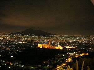
Being the area around Mount Vesuvius highly urbanized, it became necessary to develop evacuation plans to be applied when the signs of a forthcoming eruption will appear.[2] A danger zone around the volcano was first identified in 2001 by the Italian Protezione Civile; its boundaries were then redefined in 2013 following new studies on the behaviour of Plinian eruptions.[3]
The zone is composed by two subzones, called red zone 1 and 2. The former is the most dangerous area in the case of an eruption, being at greatest risk from pyroclastic flows. The red zone 2 will be subjected to falling out of ash and lapilli, whose intensity will depend on the intensity and direction of the winds at that moment.[4]
Mount Vesuvius is continuously kept under surveillance by the Vesuvius Observatory of the National Institute of Geophysics and Volcanology. When an appointed set of geologic activities occurs, an eruption warning is issued and the evacuation procedure begins.[5] It has been estimated that 72 hours are needed to complete the evacuation: 12 hours to organize it, 48 hours to transfer all the people outside the red zone and 12 hours are kept as a safety margin for unexpected events.[6]
List of comunes involved
The red zone comprises 25 comunes and part of the city of Naples, with about 800,000 residents to be evacuated.[4]
In the case of an eruption, the evacuated people will be transferred to and hosted in 19 Italian regions (Campania being excluded), according to their comune of origin.[7]
| Comune | Population[8] | Surface (km2) | Hosting region |
|---|---|---|---|
| Boscoreale | 27927 | 11.28 | Calabria |
| Boscotrecase | 10247 | 7 | Basilicata |
| Cercola | 18007 | 3 | Liguria |
| Ercolano | 52763 | 19.64 | Emilia-Romagna |
| Massa di Somma | 5353 | 3.03 | Molise |
| Naples (6th municipality only) | 138641 | 19.28 | Lazio |
| Nola | 34467 | 39 | Aosta Valley |
| Ottaviano | 23710 | 19.85 | Lazio |
| Palma Campania | 18218 | 20.8 | Friuli-Venezia Giulia |
| Poggiomarino | 21993 | 13.28 | Marche |
| Pollena Trocchia | 13478 | 8.11 | Trentino-Alto Adige |
| Pompei | 25207 | 12.4 | Sardinia |
| Portici | 54577 | 4.52 | Piedmont |
| San Gennaro Vesuviano | 11910 | 6.97 | Umbria |
| San Giorgio a Cremano | 45122 | 4.11 | Tuscany |
| San Giuseppe Vesuviano | 31612 | 14 | Veneto |
| San Sebastiano al Vesuvio | 9057 | 2 | Apulia |
| Sant'Anastasia | 27690 | 18.76 | Veneto |
| Scafati | 50686 | 19.69 | Sicily |
| Somma Vesuviana | 34981 | 30.74 | Lombardy |
| Terzigno | 18584 | 23 | Abruzzo |
| Torre Annunziata | 42406 | 7.33 | Apulia |
| Torre del Greco | 85332 | 30.66 | Lombardy |
| Trecase | 8969 | 6.14 | Sicily |
See also
References
- ↑ "What if Mount Vesuvius Erupted Today?". CBC.ca. 2017-09-03.
- ↑ Marshall, Lee (2017-09-28). "'Locals console themselves with religion': Life in the shadow of an active volcano". The Daily Telegraph.
- ↑ "From 2003 till now". Protezione Civile.
- 1 2 3 "New red zone". Protezione Civile.
- ↑ "Reference event and alert levels". Protezione Civile.
- ↑ Pasha-Robinson, Lucy (2016-10-14). "Mount Vesuvius eruption risk: Emergency plans to evacuate 700,000 finalised". The Independent.
- ↑ Edwards, Catherine (2016-10-13). "Italy puzzles over how to save 700,000 people from wrath of Vesuvius". The Local.
- ↑ Data taken from ISTAT's demographic data and referred to 31 December 2017.