Verna, Goa
| Verna | |
|---|---|
| Village | |
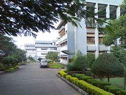 Padre Conceição College of Engineering in Verna | |
 Verna Location of Verna in Goa  Verna Verna (India) | |
| Coordinates: 15°20′57″N 73°55′53″E / 15.34917°N 73.93139°ECoordinates: 15°20′57″N 73°55′53″E / 15.34917°N 73.93139°E | |
| Country | India |
| State | Goa |
| District | South Goa |
| Sub-district | Salcete |
| Time zone | UTC+5:30 (IST) |
| Postcode | 403722 |
| Area code(s) | 0832 |
| Website |
goa |
Verna is a village in Salcete, Goa, India, adjacent to the village of Nagoa. It is located approximately 10 km north of the South Goa district headquarters Margão, 18 km south-east of Vasco da Gama and 23 km south-east of the state capital Panjim.
Geography
Verna is located in Salcete, South Goa. Its geographical coordinates are 15°20′57″N 73°55′53″E / 15.34917°N 73.93139°E.
Education
The Padre Conceição College of Engineering (PCCE) is a private engineering college in Verna. The college is a part of Agnel Technical Education Complex, Verna, Goa and is the first private engineering college in the state.
Places of worship
- Mahalasa Narayani temple at Verna plateau.[1]
- Holy Cross Church is the parish church of Verna.
By Rail
Verna Rail Way Station , Cansaulim Rail Way Station are the very nearby railway stations to Verna. How ever Madgaon Rail Way Station is major railway station 11 KM near to Verna
Airports
Airports nearest to Verna; sorted by the distance to the airport from the city centre.
- Dabolim Airport (distanced approximately 14 km)
- Belgaum Airport (distanced approximately 94 km)
- Kolhapur Airport (distanced approximately 150 km)
- Ratnagiri Airport (distanced approximately 190 km)
- Mangalore Airport (distanced approximately 290 km)
References
- ↑ "Shri Mahalasa temple at Verna". Shri Mahalasa Narayani Temple Shrikshetra Varenyapuri, Old Mardol, Verna, Salcette, GOA. Retrieved 21 May 2015.
External links
- Padre Conceicao College of Engineering official website